
Carte topographique Shahrud
Carte interactive
Cliquez sur la carte pour afficher l’altitude.
À propos de cette carte
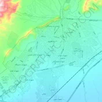
Nom : Carte topographique Shahrud, altitude, relief.
Lieu : Shahrud, بخش مرکزی, Shahrud County, Semnan Province, Iran (36.37551 54.91737 36.44660 55.02354)
Altitude moyenne : 1 375 m
Altitude minimum : 1 265 m
Altitude maximum : 1 940 m
Situated about an altitude of 1345 m, it is located at latitude 36°25'N, longitude 055°01'E. The main launch site of the Iranian Space Agency is near Shahrood. It is also well known for unique types of grapes which are cultivated specially in Shahrud. Consequently, Shahrood is known as the City of Grapes.