
Carte topographique Phon Sung
Carte interactive
Cliquez sur la carte pour afficher l’altitude.
À propos de cette carte
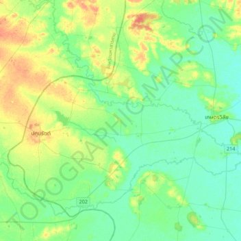
Nom : Carte topographique Phon Sung, altitude, relief.
Lieu : Phon Sung, Roi Et Province, Thailand (15.49153 103.29116 15.81153 103.61116)
Altitude moyenne : 137 m
Altitude minimum : 125 m
Altitude maximum : 163 m
Autres cartes topographiques
Cliquez sur une carte pour visualiser sa topographie, son altitude et son relief.
At Samat
Thailand > Roi Et Province > At Samat
At Samat, Roi Et Province, 45160, Thailand
Altitude moyenne : 137 m
Ban Chan
Thailand > Roi Et Province > Ban Chan
Ban Chan, Roi Et Province, Thailand
Altitude moyenne : 133 m