
Faire un don
Équipez-vous pour votre prochaine aventure :
En tant que Partenaire Amazon, ce site perçoit une commission sur les achats éligibles sans surcoût pour vous.
Carte topographique Live Oak
Cliquez sur la carte pour afficher l’altitude.
Faire un don
Équipez-vous pour votre prochaine aventure :
En tant que Partenaire Amazon, ce site perçoit une commission sur les achats éligibles sans surcoût pour vous.
Live Oak
Live Oak is a census-designated place (CDP) in Santa Cruz County, California between the cities of Santa Cruz and Capitola and north of the former Union Pacific railroad. Live Oak sits at an elevation of 102 feet (31 m). The population was 17,038 at the 2020 census. The population of the greater Live Oak area, including Twin Lakes and Pleasure Point, was 27,921.
Faire un don
Équipez-vous pour votre prochaine aventure :
En tant que Partenaire Amazon, ce site perçoit une commission sur les achats éligibles sans surcoût pour vous.
À propos de cette carte
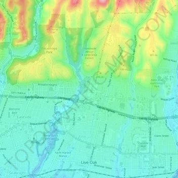
Nom : Carte topographique Live Oak, altitude, relief.
Lieu : Live Oak, Santa Cruz County, California, United States (36.96743 -122.00111 37.01334 -121.96542)
Altitude moyenne : 47 m
Altitude minimum : 0 m
Altitude maximum : 172 m
Faire un don
Équipez-vous pour votre prochaine aventure :
En tant que Partenaire Amazon, ce site perçoit une commission sur les achats éligibles sans surcoût pour vous.
Autres cartes topographiques
Cliquez sur une carte pour visualiser sa topographie, son altitude et son relief.