
Carte topographique Waihola Hill
Carte interactive
Cliquez sur la carte pour afficher l’altitude.
À propos de cette carte
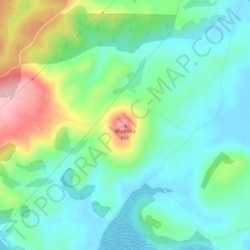
Nom : Carte topographique Waihola Hill, altitude, relief.
Lieu : Waihola Hill, Clutha District, Otago, 9243, New Zealand (-46.00530 170.05739 -46.00520 170.05749)
Altitude moyenne : 55 m
Altitude minimum : -3 m
Altitude maximum : 189 m
Autres cartes topographiques
Cliquez sur une carte pour visualiser sa topographie, son altitude et son relief.
Lawrence
New Zealand > Otago > Clutha District
Lawrence, Clutha District, Otago, 9532, New Zealand
Altitude moyenne : 163 m
Waitahuna Hill
New Zealand > Otago > Clutha District
Waitahuna Hill, Clutha District, Otago, New Zealand
Altitude moyenne : 537 m
Beaumont
New Zealand > Otago > Clutha District
Beaumont, Clutha District, Otago, New Zealand
Altitude moyenne : 122 m
Balclutha
New Zealand > Otago > Clutha District
Balclutha, Clutha District, Otago, 9230, New Zealand
Altitude moyenne : 40 m
Owaka
New Zealand > Otago > Clutha District
Owaka, Clutha District, Otago, 9535, New Zealand
Altitude moyenne : 27 m
Clinton
New Zealand > Otago > Clutha District
Clinton, Clutha District, Otago, 9534, New Zealand
Altitude moyenne : 153 m
Tokoiti
New Zealand > Otago > Clutha District > Milton > Tokoiti
Tokoiti, Milton, Clutha District, Otago, 9220, New Zealand
Altitude moyenne : 50 m
Taieri Mouth
New Zealand > Otago > Clutha District
Taieri Mouth, Clutha District, Otago, New Zealand
Altitude moyenne : 46 m
Kapiti
New Zealand > Otago > Clutha District
Kapiti, Clutha District, Otago, 9291, New Zealand
Altitude moyenne : 92 m
Tapanui Hill
New Zealand > Otago > Clutha District
Tapanui Hill, Clutha District, Otago, New Zealand
Altitude moyenne : 749 m