
Carte topographique Ilo'ilo
Carte interactive
Cliquez sur la carte pour afficher l’altitude.
À propos de cette carte
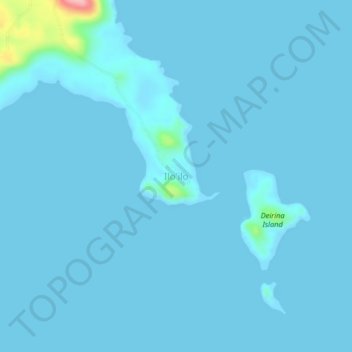
Nom : Carte topographique Ilo'ilo, altitude, relief.
Lieu : Ilo'ilo, Milne Bay, Southern Region, Papua New Guinea (-10.70852 150.40572 -10.66852 150.44572)
Altitude moyenne : 5 m
Altitude minimum : -2 m
Altitude maximum : 137 m
Autres cartes topographiques
Cliquez sur une carte pour visualiser sa topographie, son altitude et son relief.
D'Entrecasteaux Islands
D'Entrecasteaux Islands, Milne Bay, Southern Region, Papua New Guinea
Altitude moyenne : 76 m
Goodenough Island
Goodenough Island, Esa’ala District, Milne Bay, Papua Region, Papua New Guinea
Altitude moyenne : 103 m
Normanby Island
Normanby Island, Esa’ala District, Milne Bay, Papua Region, Papua New Guinea
Altitude moyenne : 49 m
Tagula Island
Tagula Island, Misima District, Milne Bay, Papua Region, Papua New Guinea
Altitude moyenne : 18 m
Woodlark Island
Woodlark Island, Losuia District, Milne Bay, Papua Region, Papua New Guinea
Altitude moyenne : 9 m
Fergusson Island
Fergusson Island, Esa’ala District, Milne Bay, Papua Region, Papua New Guinea
Altitude moyenne : 98 m
D’Entrecasteaux Islands
D’Entrecasteaux Islands, Esa’ala District, Milne Bay, Papua Region, Papua New Guinea
Altitude moyenne : 102 m