
Carte topographique Schierling
Carte interactive
Cliquez sur la carte pour afficher l’altitude.
À propos de cette carte
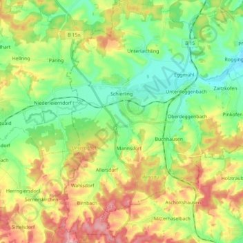
Nom : Carte topographique Schierling, altitude, relief.
Lieu : Schierling, Landkreis Regensburg, Bavaria, 84069, Germany (48.76491 12.09690 48.87883 12.25965)
Altitude moyenne : 411 m
Altitude minimum : 358 m
Altitude maximum : 493 m
Autres cartes topographiques
Cliquez sur une carte pour visualiser sa topographie, son altitude et son relief.
Mintraching
Germany > Bavaria > Landkreis Regensburg
Mintraching, Landkreis Regensburg, Bavaria, 93098, Germany
Altitude moyenne : 341 m
Wahlsdorf
Germany > Bavaria > Landkreis Regensburg
Wahlsdorf, Schierling, Landkreis Regensburg, Bavaria, 84097, Germany
Altitude moyenne : 435 m
Kallmünz
Germany > Bavaria > Landkreis Regensburg
Kallmünz, Kallmünz (VGem), Landkreis Regensburg, Bavaria, 93183, Germany
Altitude moyenne : 413 m
Brennberg
Germany > Bavaria > Landkreis Regensburg
Brennberg, Wörth an der Donau (VGem), Landkreis Regensburg, Bavaria, 93179, Germany
Altitude moyenne : 547 m