
Faire un don
Équipez-vous pour votre prochaine aventure :
En tant que Partenaire Amazon, ce site perçoit une commission sur les achats éligibles sans surcoût pour vous.
Carte topographique Bruzolo
Cliquez sur la carte pour afficher l’altitude.
Faire un don
Équipez-vous pour votre prochaine aventure :
En tant que Partenaire Amazon, ce site perçoit une commission sur les achats éligibles sans surcoût pour vous.
Bruzolo
The town of Bruzolo is the main population centre of the commune and is its capoluogo. It stands to the left of the river Dora Riparia on an alluvial fan formed over the millennia by debris deposited by the Pissaglio and other minor torrents. The municipal territory also includes farmland and factories on the flood-plain of the Dora Riparia, and extends over the forested southern slopes of Punta Lunella, elevation 2,772 metres (9,094 ft), where there is a scattering of hamlets: Campobenedetto, Meisonardi, Comba, Bigiardi, Lunera, Coletto, Chiotetti, Seinera and Combette.
Faire un don
Équipez-vous pour votre prochaine aventure :
En tant que Partenaire Amazon, ce site perçoit une commission sur les achats éligibles sans surcoût pour vous.
À propos de cette carte
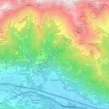
Nom : Carte topographique Bruzolo, altitude, relief.
Lieu : Bruzolo, Torino, Piemont, Italy (45.12292 7.18170 45.19538 7.21655)
Altitude moyenne : 1 224 m
Altitude minimum : 397 m
Altitude maximum : 2 696 m
Faire un don
Équipez-vous pour votre prochaine aventure :
En tant que Partenaire Amazon, ce site perçoit une commission sur les achats éligibles sans surcoût pour vous.