
Faire un don
Équipez-vous pour votre prochaine aventure :
En tant que Partenaire Amazon, ce site perçoit une commission sur les achats éligibles sans surcoût pour vous.
Carte topographique Pipa
Cliquez sur la carte pour afficher l’altitude.
Faire un don
Équipez-vous pour votre prochaine aventure :
En tant que Partenaire Amazon, ce site perçoit une commission sur les achats éligibles sans surcoût pour vous.
À propos de cette carte
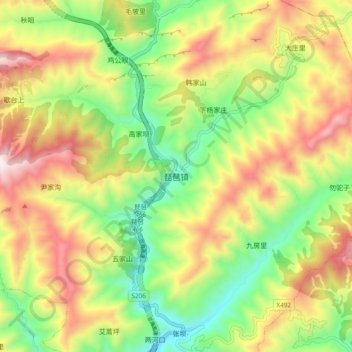
Nom : Carte topographique Pipa, altitude, relief.
Lieu : Pipa, Wudu District, Longnan, Gansu, China (33.12649 105.27457 33.20649 105.35457)
Altitude moyenne : 1 738 m
Altitude minimum : 1 296 m
Altitude maximum : 2 287 m
Faire un don
Équipez-vous pour votre prochaine aventure :
En tant que Partenaire Amazon, ce site perçoit une commission sur les achats éligibles sans surcoût pour vous.
Autres cartes topographiques
Cliquez sur une carte pour visualiser sa topographie, son altitude et son relief.
Jingtai County
The county is largely hilly and mountainous, with an elevation ranging from 1,276 metres (4,186 ft) to 3,321 metres (10,896 ft) above sea level. The county is home to a number of prominent tourist sites, such as the Yellow River Stone Forest, Yongtai Fortress, and other locations.
Altitude moyenne : 1 918 m
Faire un don
Équipez-vous pour votre prochaine aventure :
En tant que Partenaire Amazon, ce site perçoit une commission sur les achats éligibles sans surcoût pour vous.
Zhangye Danxia National Geological Park
China > Gansu > Linze County > Nantai
Altitude moyenne : 1 759 m
Faire un don
Équipez-vous pour votre prochaine aventure :
En tant que Partenaire Amazon, ce site perçoit une commission sur les achats éligibles sans surcoût pour vous.
Qingyang
Qingyang is the easternmost prefecture-level division of Gansu and is thus sometimes referred to as "Longdong" (Chinese: 陇东; pinyin: Lǒng dōng). It forms an administrative peninsula, as it is surrounded, on all sides but the south, by Shaanxi and Ningxia. It is in the lower middle part of the Yellow…
Altitude moyenne : 1 454 m
Faire un don
Équipez-vous pour votre prochaine aventure :
En tant que Partenaire Amazon, ce site perçoit une commission sur les achats éligibles sans surcoût pour vous.
Faire un don
Équipez-vous pour votre prochaine aventure :
En tant que Partenaire Amazon, ce site perçoit une commission sur les achats éligibles sans surcoût pour vous.
Faire un don
Équipez-vous pour votre prochaine aventure :
En tant que Partenaire Amazon, ce site perçoit une commission sur les achats éligibles sans surcoût pour vous.
Faire un don
Équipez-vous pour votre prochaine aventure :
En tant que Partenaire Amazon, ce site perçoit une commission sur les achats éligibles sans surcoût pour vous.
Faire un don
Équipez-vous pour votre prochaine aventure :
En tant que Partenaire Amazon, ce site perçoit une commission sur les achats éligibles sans surcoût pour vous.
Faire un don
Équipez-vous pour votre prochaine aventure :
En tant que Partenaire Amazon, ce site perçoit une commission sur les achats éligibles sans surcoût pour vous.
Faire un don
Équipez-vous pour votre prochaine aventure :
En tant que Partenaire Amazon, ce site perçoit une commission sur les achats éligibles sans surcoût pour vous.
Maqu County
Maqu County (simplified Chinese: 玛曲县; traditional Chinese: 瑪曲縣; pinyin: Mǎqū Xiàn; Tibetan: རྨ་ཆུ་རྫོང་།, Wylie: Rma chu rdzong, ZYPY: Maqu Zong) is a county of the Gannan Tibetan Autonomous Prefecture in the south of Gansu province of the People's Republic of China,…
Altitude moyenne : 3 812 m
Faire un don
Équipez-vous pour votre prochaine aventure :
En tant que Partenaire Amazon, ce site perçoit une commission sur les achats éligibles sans surcoût pour vous.
Lanzhou New Area
Lanzhou's main urban area is constrained in size by its geographical topography, since it is a typical valley sandwiched by mountains, with the Yellow River crossing by. The topography of Lanzhou hampers this city to become a continuous megacity like Beijing or Xi’an. The General Office of the State Council…
Altitude moyenne : 2 034 m
Faire un don
Équipez-vous pour votre prochaine aventure :
En tant que Partenaire Amazon, ce site perçoit une commission sur les achats éligibles sans surcoût pour vous.
Faire un don
Équipez-vous pour votre prochaine aventure :
En tant que Partenaire Amazon, ce site perçoit une commission sur les achats éligibles sans surcoût pour vous.
Faire un don
Équipez-vous pour votre prochaine aventure :
En tant que Partenaire Amazon, ce site perçoit une commission sur les achats éligibles sans surcoût pour vous.