
Carte topographique Basingstoke
Cliquez sur la carte pour afficher l’altitude.
Basingstoke
Situated in a valley through the Hampshire Downs at an average elevation of 88 metres (289 ft), Basingstoke is a major interchange between Reading, Newbury, Andover, Winchester and Alton. It lies on the natural trade route between the south-west of England and London. The area had been something of an interchange even in ancient times. It had been cut by a Roman roadway that ran from north-east to south-west, from Silchester towards Salisbury (Sorbiodunum), and by another Roman road that linked Silchester (Calleva Atrebatum) in the north with Winchester (Venta Belgarum) to the south. These cross-cutting highways, along with the good agricultural land hereabouts, account for the many Roman villas in the area, mostly put up by Romanized native nobility. Even more ancient was the Harrow Way, a Neolithic trackway, possibly associated with the ancient tin trade, that crossed all of southern England from west to east, from Cornwall to Kent, passing right through Andover and Basingstoke.
À propos de cette carte
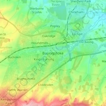
Nom : Carte topographique Basingstoke, altitude, relief.
Altitude moyenne : 107 m
Altitude minimum : 59 m
Altitude maximum : 206 m
Autres cartes topographiques
Cliquez sur une carte pour visualiser sa topographie, son altitude et son relief.
Basingstoke
United Kingdom > England > Hampshire > Basingstoke and Deane
Situated in a valley through the Hampshire Downs at an average elevation of 88 metres (289 ft) Basingstoke is a major interchange between Reading, Newbury, Andover, Winchester, and Alton, and lies on the natural trade route between the southwest of England and London. The area had been something of an…
Altitude moyenne : 109 m
Winterhill Plantation
United Kingdom > England > Hampshire > Basingstoke and Deane > Whitchurch > Wells-In-The-Field
Altitude moyenne : 100 m
Morgaston Wood
United Kingdom > England > Hampshire > Basingstoke and Deane > Sherborne St John
Altitude moyenne : 76 m
Highclere Castle
United Kingdom > England > Hampshire > Basingstoke and Deane
Altitude moyenne : 166 m
Mortimer West End
United Kingdom > England > Hampshire > Basingstoke and Deane > Mortimer West End
Altitude moyenne : 90 m
Wootton St. Lawrence
United Kingdom > England > Hampshire > Basingstoke and Deane
Altitude moyenne : 115 m
Newtown
United Kingdom > England > Hampshire > Basingstoke and Deane > Newtown
Altitude moyenne : 109 m
Sherborne St. John
United Kingdom > England > Hampshire > Basingstoke and Deane > Sherborne St John
Altitude moyenne : 79 m
Bramley Corner
United Kingdom > England > Hampshire > Basingstoke and Deane > Bramley
Altitude moyenne : 69 m
Sherfield on Loddon
United Kingdom > England > Hampshire > Basingstoke and Deane
Altitude moyenne : 66 m
Monk Sherborne
United Kingdom > England > Hampshire > Basingstoke and Deane > Monk Sherborne
Altitude moyenne : 107 m
Kingsclere
United Kingdom > England > Hampshire > Basingstoke and Deane > Kingsclere
Altitude moyenne : 139 m
Chineham
United Kingdom > England > Hampshire > Basingstoke and Deane > Basingstoke
Altitude moyenne : 78 m
River Lyde
United Kingdom > England > Hampshire > Basingstoke and Deane > Up Nately
Altitude moyenne : 78 m
Baughurst
United Kingdom > England > Hampshire > Basingstoke and Deane > Wolverton Townsend
Altitude moyenne : 106 m
St. Mary Bourne
United Kingdom > England > Hampshire > Basingstoke and Deane > Stoke
Altitude moyenne : 125 m
East Woodhay
United Kingdom > England > Hampshire > Basingstoke and Deane > East End
Altitude moyenne : 171 m
Wootton St. Lawrence
United Kingdom > England > Hampshire > Basingstoke and Deane
Altitude moyenne : 115 m
Preston Candover
United Kingdom > England > Hampshire > Basingstoke and Deane
Altitude moyenne : 130 m
Highclere
United Kingdom > England > Hampshire > Basingstoke and Deane > Highclere
Altitude moyenne : 154 m
Chineham
United Kingdom > England > Hampshire > Basingstoke and Deane > Basingstoke
Altitude moyenne : 78 m
Highclere
United Kingdom > England > Hampshire > Basingstoke and Deane > Highclere
Altitude moyenne : 154 m