
Faire un don
Équipez-vous pour votre prochaine aventure :
En tant que Partenaire Amazon, ce site perçoit une commission sur les achats éligibles sans surcoût pour vous.
Carte topographique Mount Guiting-Guiting
Cliquez sur la carte pour afficher l’altitude.
Faire un don
Équipez-vous pour votre prochaine aventure :
En tant que Partenaire Amazon, ce site perçoit une commission sur les achats éligibles sans surcoût pour vous.
Mount Guiting-Guiting
Mount Guiting-Guiting or G2 is the highest mountain in the province of Romblon, located in Sibuyan Island, in the Philippines, with an elevation of 6,752 ft (2,058 m) above sea level. Its steep slopes and jagged peak, have earned it the reputation, as one of the most difficult and technically most challenging mountain to climb in the Philippines. Ranked 11th-most prominent mountain in Philippines, and 71st-highest peak of an island in the world. Located at the heart of Sibuyan and dominates the landscape for miles around. Guiting-Guiting, in the Romblomanon dialect means "jagged". It is one of the focal points of Sibuyan's declaration as a biodiversity haven and has been dubbed by some local and international natural scientists as The Galapagos of Asia. The island of Sibuyan has been compared numerous times with the biodiversity endemism rate of the Galapagos islands in Ecuador.
Faire un don
Équipez-vous pour votre prochaine aventure :
En tant que Partenaire Amazon, ce site perçoit une commission sur les achats éligibles sans surcoût pour vous.
À propos de cette carte
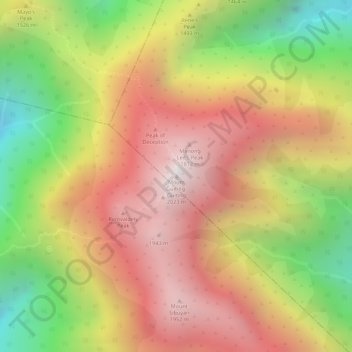
Nom : Carte topographique Mount Guiting-Guiting, altitude, relief.
Altitude moyenne : 1 478 m
Altitude minimum : 773 m
Altitude maximum : 2 010 m
Faire un don
Équipez-vous pour votre prochaine aventure :
En tant que Partenaire Amazon, ce site perçoit une commission sur les achats éligibles sans surcoût pour vous.