
Carte topographique Degerloch
Cliquez sur la carte pour afficher l’altitude.
À propos de cette carte
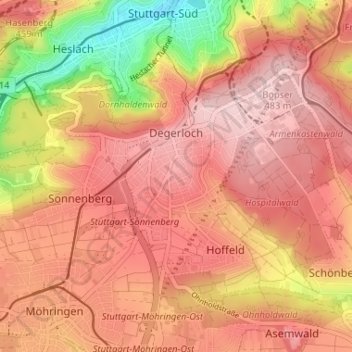
Nom : Carte topographique Degerloch, altitude, relief.
Lieu : Degerloch, Stuttgart, Baden-Württemberg, 70597, Germany (48.72921 9.13619 48.75942 9.20131)
Altitude moyenne : 414 m
Altitude minimum : 266 m
Altitude maximum : 488 m
Autres cartes topographiques
Cliquez sur une carte pour visualiser sa topographie, son altitude et son relief.
Stuttgart
Germany > Baden-Württemberg > Stuttgart
Stuttgart covers an area of 207.35 km2 (80 sq mi) and sits at elevation ranging from 207 m (679 ft) above sea level by the Neckar river to 549 m (1,801 ft) on Bernhartshöhe hill – something rather unique in large German cities. The most prominent elevated locales in Stuttgart are the Birkenkopf (511 m…
Altitude moyenne : 353 m