
Carte topographique Gotska Sandön
Carte interactive
Cliquez sur la carte pour afficher l’altitude.
À propos de cette carte
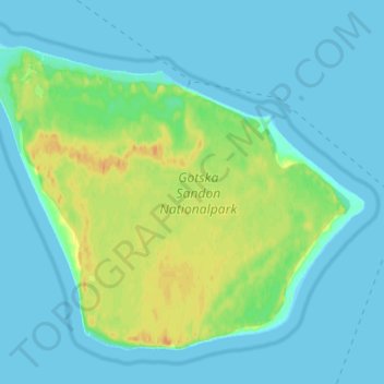
Nom : Carte topographique Gotska Sandön, altitude, relief.
Altitude moyenne : 7 m
Altitude minimum : 0 m
Altitude maximum : 29 m
Autres cartes topographiques
Cliquez sur une carte pour visualiser sa topographie, son altitude et son relief.
Burge
Sweden > Gotland County > Burge
Burge, Gotlands kommun, Gotland County, Region Götaland, Sweden
Altitude moyenne : 24 m
Lummelunda
Sweden > Gotland County > Lummelunda
Lummelunda, Gotland, Gotland County, Territorial waters of Gotland, Sweden
Altitude moyenne : 42 m