
Carte topographique Chilworth
Carte interactive
Cliquez sur la carte pour afficher l’altitude.
À propos de cette carte
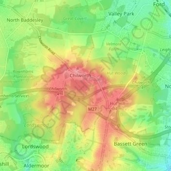
Nom : Carte topographique Chilworth, altitude, relief.
Altitude moyenne : 49 m
Altitude minimum : 8 m
Altitude maximum : 96 m
Autres cartes topographiques
Cliquez sur une carte pour visualiser sa topographie, son altitude et son relief.
Barton Stacey
United Kingdom > England > Test Valley
Barton Stacey, Test Valley, Hampshire, South East, England, United Kingdom
Altitude moyenne : 75 m
Kimpton
United Kingdom > England > Test Valley
Kimpton, Test Valley, Hampshire, South East, England, United Kingdom
Altitude moyenne : 111 m
Test Valley
United Kingdom > England > Test Valley
Test Valley, Hampshire, South East, England, United Kingdom
Altitude moyenne : 97 m
Romsey
United Kingdom > England > Test Valley
Romsey, Test Valley, Hampshire, South East, England, United Kingdom
Altitude moyenne : 25 m