
Carte topographique Hof am Regen
Carte interactive
Cliquez sur la carte pour afficher l’altitude.
À propos de cette carte
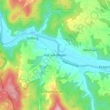
Nom : Carte topographique Hof am Regen, altitude, relief.
Altitude moyenne : 418 m
Altitude minimum : 337 m
Altitude maximum : 590 m
Autres cartes topographiques
Cliquez sur une carte pour visualiser sa topographie, son altitude et son relief.
Gunt
Deutschland > Bayern > Landkreis Schwandorf > Nittenau > Hof am Regen
Gunt, Hof am Regen, Nittenau, Landkreis Schwandorf, Bayern, 93149, Deutschland
Altitude moyenne : 424 m