
Carte topographique Kobylany
Carte interactive
Cliquez sur la carte pour afficher l’altitude.
À propos de cette carte
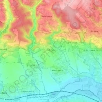
Nom : Carte topographique Kobylany, altitude, relief.
Altitude moyenne : 319 m
Altitude minimum : 225 m
Altitude maximum : 465 m
Autres cartes topographiques
Cliquez sur une carte pour visualiser sa topographie, son altitude et son relief.
Werychów
Poland > Lesser Poland Voivodeship > Kraków County > Balice
Werychów, Balice, gmina Zabierzów, Kraków County, Lesser Poland Voivodeship, 31-083, Poland
Altitude moyenne : 238 m
Bielańsko-Tyniecki Park Krajobrazowy
Poland > Lesser Poland Voivodeship > Kraków County > Krakow
Bielańsko-Tyniecki Park Krajobrazowy, Krakow, gmina Liszki, Kraków County, Lesser Poland Voivodeship, Poland
Altitude moyenne : 239 m
Podzamcze
Poland > Lesser Poland Voivodeship > Kraków County > Korzkiew > Podzamcze
Podzamcze, Korzkiew, gmina Zielonki, Kraków County, Lesser Poland Voivodeship, Poland
Altitude moyenne : 321 m
Czernichów
Poland > Lesser Poland Voivodeship > Kraków County
Czernichów, gmina Czernichów, Kraków County, Lesser Poland Voivodeship, Poland
Altitude moyenne : 219 m
Libertów
Poland > Lesser Poland Voivodeship > Kraków County
Libertów, gmina Mogilany, Kraków County, Lesser Poland Voivodeship, 30-444, Poland
Altitude moyenne : 270 m
Radziszów
Poland > Lesser Poland Voivodeship > Kraków County
Radziszów, gmina Skawina, Kraków County, Lesser Poland Voivodeship, Poland
Altitude moyenne : 262 m