
Carte topographique Kwabre East Municipal District
Carte interactive
Cliquez sur la carte pour afficher l’altitude.
À propos de cette carte
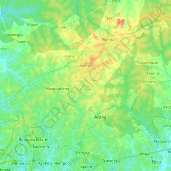
Nom : Carte topographique Kwabre East Municipal District, altitude, relief.
Lieu : Kwabre East Municipal District, Ashanti Region, Ghana (6.72560 -1.62357 6.85348 -1.45169)
Altitude moyenne : 296 m
Altitude minimum : 245 m
Altitude maximum : 416 m
Autres cartes topographiques
Cliquez sur une carte pour visualiser sa topographie, son altitude et son relief.
Hwereso
Ghana > Ashanti Region > Ejisu Municipal District
Hwereso, Ejisu Municipal District, Ashanti Region, Ghana
Altitude moyenne : 224 m
Boankra
Ghana > Ashanti Region > Ejisu Municipal District
Boankra, Ejisu Municipal District, Ashanti Region, Ghana
Altitude moyenne : 234 m
Sekyere South District
Sekyere South District, Ashanti Region, Ghana
Altitude moyenne : 334 m
Agona-Bipoa
Ghana > Ashanti Region > Sekyere South District
Agona-Bipoa, Sekyere South District, Ashanti Region, Ghana
Altitude moyenne : 289 m
Akuntam
Ghana > Ashanti Region > Amansie South District
Akuntam, Amansie South District, Ashanti Region, Ghana
Altitude moyenne : 183 m
Mampong
Ghana > Ashanti Region > Mampong Municipal District
Mampong, Mampong Municipal District, Ashanti Region, Ghana
Altitude moyenne : 395 m
Agogo
Ghana > Ashanti Region > Asante-Akim North District
Agogo, Asante-Akim North District, Ashanti Region, Ghana
Altitude moyenne : 408 m
Konongo
Ghana > Ashanti Region > Asante-Akim Central Municipal District
Konongo, Asante-Akim Central Municipal District, Ashanti Region, Ghana
Altitude moyenne : 232 m
Lake Bosumtwi
Ghana > Ashanti Region > Bosomtwe District > Nkawi
Lake Bosumtwi, Nkawi, Bosomtwe District, Ashanti Region, Ghana
Altitude moyenne : 117 m
Kumasi
Ghana > Ashanti Region > Kumasi Metropolitan District
Kumasi, Kumasi Metropolitan District, Ashanti Region, Ghana
Altitude moyenne : 256 m
Obuasi
Ghana > Ashanti Region > Obuasi Municipal District
Obuasi, Obuasi Municipal District, Ashanti Region, Ghana
Altitude moyenne : 196 m
Ejisu
Ghana > Ashanti Region > Ejisu Municipal District > Ejisu
Ejisu, Ejisu Municipal District, Ashanti Region, Ghana
Altitude moyenne : 276 m
Oforikrom Municipal District
Oforikrom Municipal District, Ashanti Region, Ghana
Altitude moyenne : 260 m
Old Tafo Municipal District
Ghana > Ashanti Region > Old Tafo Municipal District
Old Tafo Municipal District, Ashanti Region, Ghana
Altitude moyenne : 286 m
Juaben Municipal District
Juaben Municipal District, Ashanti Region, P. O. BOX 31, Ghana
Altitude moyenne : 257 m
Agona
Ghana > Ashanti Region > Sekyere South District
Agona, Sekyere South District, Ashanti Region, Ghana
Altitude moyenne : 287 m
Sekyere East District
Ghana > Ashanti Region > Sekyere East District
Sekyere East District, Ashanti Region, AR0000, Ghana
Altitude moyenne : 275 m
Pemenasi
Ghana > Ashanti Region > Juaben Municipal District
Pemenasi, Juaben Municipal District, Ashanti Region, Ghana
Altitude moyenne : 207 m
Asante-Akim Central Municipal District
Ghana > Ashanti Region > Asante-Akim Central Municipal District
Asante-Akim Central Municipal District, Ashanti Region, Ghana
Altitude moyenne : 233 m
New Koforidua
Ghana > Ashanti Region > New Koforidua
New Koforidua, Ashanti Region, Ghana
Altitude moyenne : 209 m
Akuapim
Ghana > Ashanti Region > Akuapim
Akuapim, Amansie Central District, Ashanti Region, Ghana
Altitude moyenne : 248 m