
Faire un don
Équipez-vous pour votre prochaine aventure :
En tant que Partenaire Amazon, ce site perçoit une commission sur les achats éligibles sans surcoût pour vous.
Carte topographique Golan
Cliquez sur la carte pour afficher l’altitude.
Faire un don
Équipez-vous pour votre prochaine aventure :
En tant que Partenaire Amazon, ce site perçoit une commission sur les achats éligibles sans surcoût pour vous.
À propos de cette carte
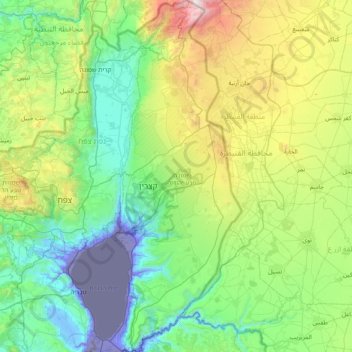
Nom : Carte topographique Golan, altitude, relief.
Lieu : Golan, Sous-district du Golan, District nord, Israël (32.68213 35.61332 33.33563 35.89502)
Altitude moyenne : 524 m
Altitude minimum : -222 m
Altitude maximum : 2 351 m
Faire un don
Équipez-vous pour votre prochaine aventure :
En tant que Partenaire Amazon, ce site perçoit une commission sur les achats éligibles sans surcoût pour vous.
Autres cartes topographiques
Cliquez sur une carte pour visualiser sa topographie, son altitude et son relief.
Mont Hermon
Israël > District nord > Golan
Le mont Hermon (appelé en hébreu : הר חרמון, Har Hermon ; et en arabe : جبل الشيخ, Jabal ash-Shaykh, soit « montagne du cheikh » ou « mont enneigé » ou Haramoun) est une montagne de l'Anti-Liban, culminant à 2 814 mètres d'altitude.
Altitude moyenne : 2 016 m
Faire un don
Équipez-vous pour votre prochaine aventure :
En tant que Partenaire Amazon, ce site perçoit une commission sur les achats éligibles sans surcoût pour vous.
Faire un don
Équipez-vous pour votre prochaine aventure :
En tant que Partenaire Amazon, ce site perçoit une commission sur les achats éligibles sans surcoût pour vous.
הר מירון
Israël > District nord > Conseil Régional Merom HaGalil
Le mont Méron (en hébreu : הר מירון, Har Meron ; en arabe : جبل الجرمق, Djabal al-Djarmaq) est avec 1 208 m d'altitude le point culminant d'Israël hors le Golan ; il est situé en Galilée. Il abrite l'une des plus grandes et la plus élevée des réserves naturelles du pays, traversée par…
Altitude moyenne : 943 m
Faire un don
Équipez-vous pour votre prochaine aventure :
En tant que Partenaire Amazon, ce site perçoit une commission sur les achats éligibles sans surcoût pour vous.
Kiryat Shmona
La cité de Kiryat Shmona est située dans le doigt de la Galilée, au sein de la vallée de la Houla, à environ cinq kilomètres au sud et deux kilomètres à l'est de la frontière avec le Liban. Son altitude est d'environ 150 mètres.
Altitude moyenne : 236 m
Faire un don
Équipez-vous pour votre prochaine aventure :
En tant que Partenaire Amazon, ce site perçoit une commission sur les achats éligibles sans surcoût pour vous.
Alonei Abba
Israël > District nord > Conseil régional de la vallée de Jezreel
Altitude moyenne : 149 m
Faire un don
Équipez-vous pour votre prochaine aventure :
En tant que Partenaire Amazon, ce site perçoit une commission sur les achats éligibles sans surcoût pour vous.