
Carte topographique Khetri Tehsil
Carte interactive
Cliquez sur la carte pour afficher l’altitude.
À propos de cette carte
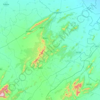
Nom : Carte topographique Khetri Tehsil, altitude, relief.
Lieu : Khetri Tehsil, Jhunjhunun, Rajasthan, 333503, India (27.79300 75.60362 28.11673 76.03554)
Altitude moyenne : 398 m
Altitude minimum : 301 m
Altitude maximum : 979 m
Autres cartes topographiques
Cliquez sur une carte pour visualiser sa topographie, son altitude et son relief.
Jolanda
India > Rajasthan > Malarna Doongar Tehsil
Jolanda, Malarna Doongar Tehsil, Sawai Madhopur District, Rajasthan, 322024, India
Altitude moyenne : 247 m
Padola
India > Rajasthan > Kumher Tehsil > Padola
Padola, Kumher Tehsil, Bharatpur, Rajasthan, 321201, India
Altitude moyenne : 187 m