
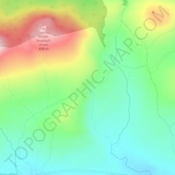
Carte topographique Liscarrigane
Carte interactive
Cliquez sur la carte pour afficher l’altitude.
À propos de cette carte
Nom : Carte topographique Liscarrigane, altitude, relief.
Altitude moyenne : 240 m
Altitude minimum : 144 m
Altitude maximum : 412 m
Autres cartes topographiques
Cliquez sur une carte pour visualiser sa topographie, son altitude et son relief.
Newcestown
Newcestown, Murragh, Blarney - Macroom, County Cork, Munster, Ireland
Altitude moyenne : 156 m
Aherla
Aherla, Kilbonane, Blarney - Macroom, County Cork, Munster, Ireland
Altitude moyenne : 84 m
Blarney
Blarney, Blarney - Macroom, Cork City 2019, County Cork, Munster, T23 VY22, Ireland
Altitude moyenne : 97 m
Kilcullen
Kilcullen, Blarney - Macroom, County Cork, Munster, Ireland
Altitude moyenne : 216 m
Inishcarra
Inishcarra, Carrigrohane Beg, Blarney - Macroom, County Cork, Munster, P31 HY26, Ireland
Altitude moyenne : 72 m
Clondrohid
Clondrohid, Blarney - Macroom, County Cork, Munster, Ireland
Altitude moyenne : 151 m
Cloghduff
Cloghduff, Moviddy, Blarney - Macroom, County Cork, Munster, Ireland
Altitude moyenne : 101 m
Seefin
Seefin, Blarney - Macroom, County Cork, Munster, Ireland
Altitude moyenne : 384 m
Killumney
Killumney, Ballygroman, Blarney - Macroom, County Cork, Munster, Ireland
Altitude moyenne : 81 m
Mullaghanish
Mullaghanish, Blarney - Macroom, County Cork, Munster, Ireland
Altitude moyenne : 474 m
Clearagh
Clearagh, Greenville, Blarney - Macroom, County Cork, Munster, Ireland
Altitude moyenne : 190 m
Cloghroe
Ireland > Blarney - Macroom > Cloghroe
Cloghroe, Blarney - Macroom, County Cork, Munster, T23 YX51, Ireland
Altitude moyenne : 77 m
Musheramore
Musheramore, Blarney - Macroom, County Cork, Munster, Ireland
Altitude moyenne : 429 m