
Faire un don
Équipez-vous pour votre prochaine aventure :
En tant que Partenaire Amazon, ce site perçoit une commission sur les achats éligibles sans surcoût pour vous.
Carte topographique Stupava
Cliquez sur la carte pour afficher l’altitude.
Faire un don
Équipez-vous pour votre prochaine aventure :
En tant que Partenaire Amazon, ce site perçoit une commission sur les achats éligibles sans surcoût pour vous.
Stupava
The town is located in the Záhorie lowland, under the Little Carpathians, around 15 km (9 mi) north of Bratislava at an altitude of 182 metres. It has 15, 095 inhabitants as of 2021 and has a land area of 67.17 km2 (26 sq mi). Apart from the core part of the city, Mást (German: Maaßt, Hungarian: Mászt), located just south of the core part of the city, is another part of Stupava. It has been initially a separate village with ethnic Croatian majority, which was formally annexed by Stupava in 1953.
Faire un don
Équipez-vous pour votre prochaine aventure :
En tant que Partenaire Amazon, ce site perçoit une commission sur les achats éligibles sans surcoût pour vous.
À propos de cette carte
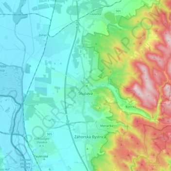
Nom : Carte topographique Stupava, altitude, relief.
Altitude moyenne : 237 m
Altitude minimum : 137 m
Altitude maximum : 540 m
Faire un don
Équipez-vous pour votre prochaine aventure :
En tant que Partenaire Amazon, ce site perçoit une commission sur les achats éligibles sans surcoût pour vous.
Autres cartes topographiques
Cliquez sur une carte pour visualiser sa topographie, son altitude et son relief.
Bratislava
Slovakia > Region of Bratislava > District of Bratislava I > Old Town
The Carpathian mountain range begins in city territory with the Little Carpathians (Malé Karpaty). The Záhorie and Danubian lowlands stretch into Bratislava. The city's lowest point is at the Danube's surface at 126 metres (413 ft) above mean sea level, and the highest point is Devínska Kobyla at 514 metres…
Altitude moyenne : 175 m
Danube
Slovakia > Region of Bratislava > District of Senec > Bratislava > Čunovo
Altitude moyenne : 125 m
Faire un don
Équipez-vous pour votre prochaine aventure :
En tant que Partenaire Amazon, ce site perçoit une commission sur les achats éligibles sans surcoût pour vous.
Veľkobielske jazero "Šutrovka"
Slovakia > Region of Bratislava > District of Senec > Veľký Biel
Altitude moyenne : 127 m
Devín Castle
Slovakia > Region of Bratislava > Bratislava > District of Bratislava IV > Devín
The cliff (elevation 212 meters) is an ideal place for a fort due to its position at the confluence of the Danube and Morava rivers. The fort watches over an important trade route along the Danube as well as one branch of the Amber Road.
Altitude moyenne : 175 m
Old Town
Slovakia > Region of Bratislava > District of Bratislava I > Old Town > Old Town
Altitude moyenne : 159 m
Faire un don
Équipez-vous pour votre prochaine aventure :
En tant que Partenaire Amazon, ce site perçoit une commission sur les achats éligibles sans surcoût pour vous.
Častá
Slovakia > Region of Bratislava > District of Pezinok
The village lies at an altitude of 245 meters and covers an area of 35.24 km². It has population of 2,078 people.
Altitude moyenne : 262 m