
Carte topographique Gródek
Carte interactive
Cliquez sur la carte pour afficher l’altitude.
À propos de cette carte
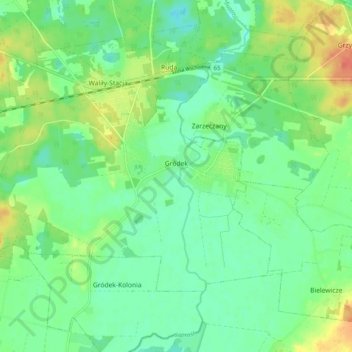
Nom : Carte topographique Gródek, altitude, relief.
Altitude moyenne : 147 m
Altitude minimum : 132 m
Altitude maximum : 172 m
Autres cartes topographiques
Cliquez sur une carte pour visualiser sa topographie, son altitude et son relief.
Mostowlany
Poland > Podlaskie Voivodeship > Białystok County
Mostowlany, gmina Gródek, Białystok County, Podlaskie Voivodeship, Poland
Altitude moyenne : 149 m
Michałowo
Poland > Podlaskie Voivodeship > Białystok County
Michałowo, gmina Michałowo, Białystok County, Podlaskie Voivodeship, Poland
Altitude moyenne : 150 m
Zabłudów
Poland > Podlaskie Voivodeship > Białystok County
Zabłudów, gmina Zabłudów, Białystok County, Podlaskie Voivodeship, 16-060, Poland
Altitude moyenne : 155 m
Mińce
Poland > Podlaskie Voivodeship > Białystok County > Mińce
Mińce, gmina Choroszcz, Białystok County, Podlaskie Voivodeship, Poland
Altitude moyenne : 137 m
Wasilków
Poland > Podlaskie Voivodeship > Białystok County
Wasilków, gmina Wasilków, Białystok County, Podlaskie Voivodeship, 16-010, Poland
Altitude moyenne : 136 m
Krynica
Poland > Podlaskie Voivodeship > Białystok County
Krynica, gmina Michałowo, Białystok County, Podlaskie Voivodeship, Poland
Altitude moyenne : 152 m