
Carte topographique The Municipal District of Bandon-Kinsale
Carte interactive
Cliquez sur la carte pour afficher l’altitude.
À propos de cette carte
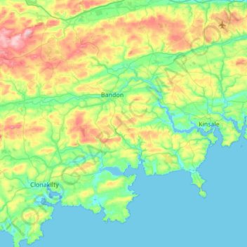
Nom : Carte topographique The Municipal District of Bandon-Kinsale, altitude, relief.
Altitude moyenne : 69 m
Altitude minimum : 0 m
Altitude maximum : 285 m
Autres cartes topographiques
Cliquez sur une carte pour visualiser sa topographie, son altitude et son relief.
Aherla
Aherla, Municipal District of Macroom, Comté de Cork, Munster, Irlande
Altitude moyenne : 91 m
Mountbridget
Mountbridget, Churchtown ED, The Municipal District of Kanturk-Mallow, Comté de Cork, Munster, Irlande
Altitude moyenne : 121 m
Ringaskiddy
Ringaskiddy, Municipal District of Carrigaline, Comté de Cork, Munster, P43 A062, Irlande
Altitude moyenne : 13 m
Toormore
Toormore, West Cork, Comté de Cork, Munster, Irlande
Altitude moyenne : 33 m
Bere Island
Bere Island, West Cork, Comté de Cork, Munster, Irlande
Altitude moyenne : 28 m
Dromore
Dromore, The Municipal District of Kanturk-Mallow, Comté de Cork, Munster, Irlande
Altitude moyenne : 170 m
Castletownroche
Castletownroche, The Municipal District of Fermoy, Comté de Cork, Munster, Irlande
Altitude moyenne : 67 m
Reanascreena South
Reanascreena South, Cahermore ED, West Cork, Comté de Cork, Munster, Irlande
Altitude moyenne : 146 m
Donegal
Irlande > Comté de Cork > Municipal District of Cobh
Donegal, Cobh Rural ED, Municipal District of Cobh, Comté de Cork, Munster, Irlande
Altitude moyenne : 31 m
Municipal District of Carrigaline
Municipal District of Carrigaline, Comté de Cork, Munster, Irlande
Altitude moyenne : 52 m
Windsor
Irlande > Comté de Cork > Municipal District of Macroom
Windsor, Ballincollig ED, Municipal District of Macroom, Comté de Cork, Munster, Irlande
Altitude moyenne : 150 m
Douglas
Irlande > Comté de Cork > Cork
Douglas, Cork, Comté de Cork, Munster, Irlande
Altitude moyenne : 34 m
Clonakilty Poor Law Union
Clonakilty Poor Law Union, Comté de Cork, Munster, Irlande
Altitude moyenne : 58 m
Ardgroom
Ardgroom, West Cork, Comté de Cork, Munster, Irlande
Altitude moyenne : 56 m