
Carte topographique Acadia National Park
Carte interactive
Cliquez sur la carte pour afficher l’altitude.
Acadia National Park
The ecological zones at Acadia National Park, from highest to lowest elevation, include: nearly barren mountain summits; northern boreal and eastern deciduous forests on the mountainsides; freshwater lakes and ponds, as well as wetlands like marshes and swamps in the valleys between mountains; and the Atlantic shoreline with rocky and sandy beaches, intertidal and subtidal zones.
À propos de cette carte
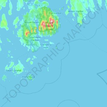
Nom : Carte topographique Acadia National Park, altitude, relief.
Altitude moyenne : 9 m
Altitude minimum : -3 m
Altitude maximum : 452 m
Autres cartes topographiques
Cliquez sur une carte pour visualiser sa topographie, son altitude et son relief.
Cadillac Mountain
United States > Maine > Hancock County > Bar Harbor
Cadillac Mountain is located on Mount Desert Island, within Acadia National Park, in the U.S. state of Maine. With an elevation of 1,530 feet (470 meters), its summit is the highest point in Hancock County and the highest within 25 miles (40 km) of the Atlantic shoreline of the North American continent between…
Altitude moyenne : 233 m