
Carte topographique Bacolod
Carte interactive
Cliquez sur la carte pour afficher l’altitude.
À propos de cette carte
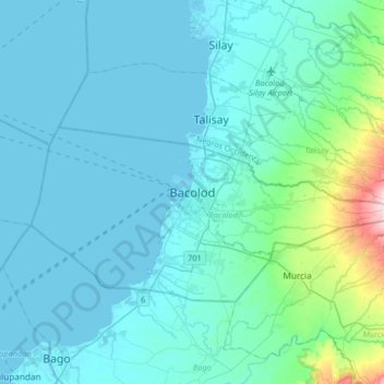
Nom : Carte topographique Bacolod, altitude, relief.
Altitude moyenne : 49 m
Altitude minimum : -1 m
Altitude maximum : 495 m
Bacólod (English: Bacolod), is derived from bakólod (Old Spelling: bacólod), the Old Hiligaynon (Old Ilonggo) (Old Spelling: Ylongo and Ilongo) word for a "hill, mound, rise, hillock, down, any small eminence or elevation", since the resettlement was founded on a stony, hilly area, now the barangay of Granada. It was officially called Ciudad de Bacólod (City of Bacolod) when Municipalidad de Bacólod (Municipality of Bacolod) was converted into a city in 1938.
Autres cartes topographiques
Cliquez sur une carte pour visualiser sa topographie, son altitude et son relief.
Estefania
Philippines > Negros Occidental > Bacolod > Estefania
Estefania, Bacolod, Negros Occidental, Western Visayas, 6100, Philippines
Altitude moyenne : 56 m