
Faire un don
Équipez-vous pour votre prochaine aventure :
En tant que Partenaire Amazon, ce site perçoit une commission sur les achats éligibles sans surcoût pour vous.
Carte topographique Sibuyan Island
Cliquez sur la carte pour afficher l’altitude.
Faire un don
Équipez-vous pour votre prochaine aventure :
En tant que Partenaire Amazon, ce site perçoit une commission sur les achats éligibles sans surcoût pour vous.
Sibuyan Island
Sibuyan is a crescent-shaped island, the second largest in an archipelago comprising Romblon Province, Philippines. Located in the namesake Sibuyan Sea, it has an area of 445 square kilometres (172 sq mi) and has a total population of 62,815, as of the 2020 census. The island has two prominent peaks, the highest is Mount Guiting-Guiting, with an elevation of 2,058 metres (6,752 ft), followed by Mount Nailog, which is 789 metres (2,589 ft) high. The people speak the Sibuyanon dialect of Romblomanon, a Visayan language.
Faire un don
Équipez-vous pour votre prochaine aventure :
En tant que Partenaire Amazon, ce site perçoit une commission sur les achats éligibles sans surcoût pour vous.
À propos de cette carte
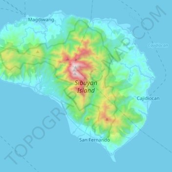
Nom : Carte topographique Sibuyan Island, altitude, relief.
Lieu : Sibuyan Island, Romblon, Mimaropa, Philippines (12.26705 122.42342 12.50612 122.69900)
Altitude moyenne : 182 m
Altitude minimum : -1 m
Altitude maximum : 1 991 m
Faire un don
Équipez-vous pour votre prochaine aventure :
En tant que Partenaire Amazon, ce site perçoit une commission sur les achats éligibles sans surcoût pour vous.
Autres cartes topographiques
Cliquez sur une carte pour visualiser sa topographie, son altitude et son relief.