
Carte topographique Bozeman
Carte interactive
Cliquez sur la carte pour afficher l’altitude.
À propos de cette carte
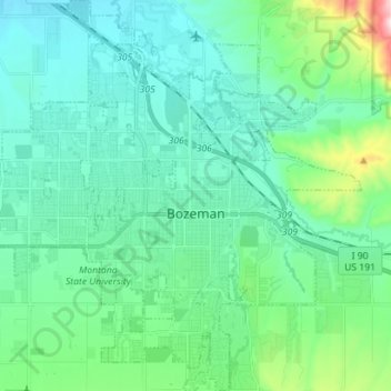
Nom : Carte topographique Bozeman, altitude, relief.
Lieu : Bozeman, Gallatin County, Montana, United States (45.63479 -111.11982 45.73326 -110.98424)
Altitude moyenne : 1 495 m
Altitude minimum : 1 392 m
Altitude maximum : 1 974 m
Bozeman is located at an elevation of 4,820 feet (1,470 m). The Bridger Mountains are to the north-northeast, the Tobacco Root Mountains to the west-southwest, the Big Belt Mountains and Horseshoe Hills to the northwest, the Hyalite Peaks of the northern Gallatin Range to the south and the Spanish Peaks of the northern Madison Range to the south-southwest. Bozeman is east of the continental divide, and Interstate 90 passes through the city. It is 84 miles (135 km) east of Butte, 125 miles (201 km) west of Billings, and 93 miles (150 km) north of Yellowstone National Park.
Autres cartes topographiques
Cliquez sur une carte pour visualiser sa topographie, son altitude et son relief.
Belgrade
United States > Montana > Gallatin County
Belgrade, Gallatin County, Montana, 59714, United States
Altitude moyenne : 1 355 m
Lightning Lake
United States > Montana > Gallatin County
Lightning Lake, Gallatin County, Montana, United States
Altitude moyenne : 2 690 m
Big Sky
United States > Montana > Gallatin County
Big Sky, Gallatin County, Montana, United States
Altitude moyenne : 2 435 m
Bozeman
United States > Montana > Gallatin County > Bozeman
Bozeman, Gallatin County, Montana, 59715, United States
Altitude moyenne : 1 679 m
Springhill
United States > Montana > Gallatin County > Springhill
Springhill, Gallatin County, Montana, United States
Altitude moyenne : 1 491 m