Géolocaliser

Carte topographique Barham

Cliquez sur la carte pour afficher l’altitude.

À propos de cette carte

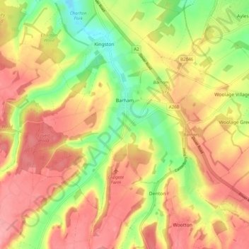
Nom : Carte topographique Barham, altitude, relief.

Lieu : Barham, Canterbury, Kent, England, United Kingdom (51.17719 1.09728 51.21975 1.19547)

Altitude moyenne : 99 m

Altitude minimum : 35 m

Altitude maximum : 148 m

Autres cartes topographiques

Cliquez sur une carte pour visualiser sa topographie, son altitude et son relief.

Hillborough

United Kingdom > England > Kent > Canterbury

Altitude moyenne : 15 m

Broomfield

United Kingdom > England > Kent > Canterbury

Altitude moyenne : 25 m

Blean

United Kingdom > England > Kent > Canterbury

Altitude moyenne : 66 m

Tankerton

United Kingdom > England > Kent > Canterbury

Altitude moyenne : 8 m

Reculver

United Kingdom > England > Kent > Canterbury

Altitude moyenne : 5 m

Clapham Hill

United Kingdom > England > Kent > Canterbury > Seasalter

Altitude moyenne : 29 m

Canterbury

United Kingdom > England > Kent > Canterbury

Altitude moyenne : 50 m

Pean Hill

United Kingdom > England > Kent > Canterbury

Altitude moyenne : 52 m

Stodmarsh

United Kingdom > England > Kent > Canterbury > Wickhambreaux

Altitude moyenne : 12 m

Herne

United Kingdom > England > Kent > Canterbury

Altitude moyenne : 30 m

Rough Common

United Kingdom > England > Kent > Canterbury

Altitude moyenne : 55 m

Broad Oak

United Kingdom > England > Kent > Canterbury

Altitude moyenne : 36 m

Harbledown

United Kingdom > England > Kent > Canterbury

Altitude moyenne : 41 m

Seasalter

United Kingdom > England > Kent > Canterbury

Altitude moyenne : 12 m

Upper Harbledown

United Kingdom > England > Kent > Canterbury

Altitude moyenne : 60 m

Ickham

United Kingdom > England > Kent > Canterbury

Altitude moyenne : 18 m

Denstroude

United Kingdom > England > Kent > Canterbury

Altitude moyenne : 54 m

Maypole

United Kingdom > England > Kent > Canterbury > Hoath > Maypole

Altitude moyenne : 26 m

Tyler Hill

United Kingdom > England > Kent > Canterbury

Altitude moyenne : 56 m

Lower Hardres

United Kingdom > England > Kent > Canterbury

Altitude moyenne : 86 m

Marshside

United Kingdom > England > Kent > Canterbury > Marshside

Altitude moyenne : 13 m

Honey Hill

United Kingdom > England > Kent > Canterbury > Blean

Altitude moyenne : 61 m

Swalecliffe

United Kingdom > England > Kent > Canterbury

Altitude moyenne : 8 m

Anvil Green

United Kingdom > England > Kent > Canterbury > Waltham

Altitude moyenne : 119 m

Breach

United Kingdom > England > Kent > Canterbury > Barham

Altitude moyenne : 105 m

Harbledown

United Kingdom > England > Kent > Canterbury

Altitude moyenne : 41 m

Tankerton

United Kingdom > England > Kent > Canterbury

Altitude moyenne : 8 m

Reculver

United Kingdom > England > Kent > Canterbury

Altitude moyenne : 5 m

Harbledown

United Kingdom > England > Kent > Canterbury

Altitude moyenne : 41 m

Équipez-vous pour votre prochaine aventure :

🧤Gants de randonnée - Gants techniques pour protection et confort
🌧️Poncho de Pluie Respirant - Protection intégrale contre les intempéries en montagne
🧺Sacs Étanches - Protégez vos vêtements et votre électronique de l'humidité
🔋Piles Rechargeables - Alimentation durable pour GPS et lampes de poche
🥤Sac d'Hydratation Trail - Système de boisson intégré pour un accès rapide sans s'arrêter

En tant que Partenaire Amazon, ce site perçoit une commission sur les achats éligibles sans surcoût pour vous.