
Carte topographique Curitiba
Carte interactive
Cliquez sur la carte pour afficher l’altitude.
À propos de cette carte
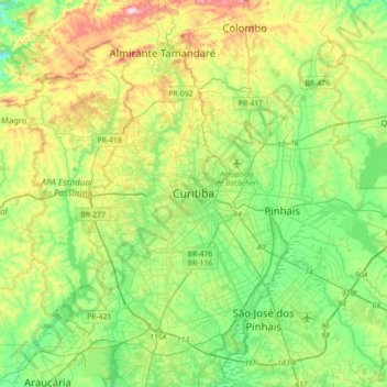
Nom : Carte topographique Curitiba, altitude, relief.
Altitude moyenne : 931 m
Altitude minimum : 802 m
Altitude maximum : 1 207 m
The city covers 432.17 km2 (166.86 sq mi) on the First Plateau of Paraná. Curitiba has a topography of smooth, rounded hills, giving it a relatively regular shape. The city has an average altitude of 934.6 m (3,066 ft) above sea level. The highest point is to the north at 1,021 m (3,350 ft), and with lower altitudes at 864 m (2,835 ft) to the south. Mountain ranges and sets of rocky hills surround parts of the city, including the Serra do Mar, a hill range between the shore of the Atlantic Ocean and the First Plateau in Paraná.