
Faire un don
Équipez-vous pour votre prochaine aventure :
En tant que Partenaire Amazon, ce site perçoit une commission sur les achats éligibles sans surcoût pour vous.
Carte topographique les Preses
Cliquez sur la carte pour afficher l’altitude.
Faire un don
Équipez-vous pour votre prochaine aventure :
En tant que Partenaire Amazon, ce site perçoit une commission sur les achats éligibles sans surcoût pour vous.
À propos de cette carte
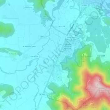
Nom : Carte topographique les Preses, altitude, relief.
Lieu : les Preses, Garrotxa, Gerona, Cataluña, 17178, España (42.12923 2.45365 42.16867 2.49816)
Altitude moyenne : 520 m
Altitude minimum : 439 m
Altitude maximum : 914 m
Faire un don
Équipez-vous pour votre prochaine aventure :
En tant que Partenaire Amazon, ce site perçoit une commission sur les achats éligibles sans surcoût pour vous.
Autres cartes topographiques
Cliquez sur une carte pour visualiser sa topographie, son altitude et son relief.
Castellfollit de la Roca
España > Cataluña > Garrotxa > Castellfollit de la Roca > Castellfollit de la Roca
Altitude moyenne : 394 m
Puigsacalm
España > Cataluña > Garrotxa > la Vall d'en Bas
El Puigsacalm es una montaña de 1515 metros de altitud que se encuentra en el municipio de la Vall de Bas, en la comarca de La Garrocha (Cataluña, España). Es el punto más alto de la cordillera Transversal.
Altitude moyenne : 1 117 m
Santa Margarida de Bianya
España > Cataluña > Garrotxa > la Vall de Bianya > l'Hostalnou de Bianya
Altitude moyenne : 467 m
Faire un don
Équipez-vous pour votre prochaine aventure :
En tant que Partenaire Amazon, ce site perçoit une commission sur les achats éligibles sans surcoût pour vous.
Faire un don
Équipez-vous pour votre prochaine aventure :
En tant que Partenaire Amazon, ce site perçoit une commission sur les achats éligibles sans surcoût pour vous.
Reserva natural parcial de Turó de la Pomareda
España > Cataluña > Garrotxa > Olot
Altitude moyenne : 626 m
Faire un don
Équipez-vous pour votre prochaine aventure :
En tant que Partenaire Amazon, ce site perçoit une commission sur les achats éligibles sans surcoût pour vous.
Volcán de Santa Margarita
España > Cataluña > Garrotxa > Santa Pau
Es uno de los más importantes del sector, de 682 metros de altitud y su boca tiene un perímetro de 2000 metros. En el centro del llano formado por el cráter se encuentra la iglesia de Santa Margarita, de origen románico. Su última erupción data de hace 11 000 años.
Altitude moyenne : 640 m
Faire un don
Équipez-vous pour votre prochaine aventure :
En tant que Partenaire Amazon, ce site perçoit une commission sur les achats éligibles sans surcoût pour vous.