
Faire un don
Équipez-vous pour votre prochaine aventure :
En tant que Partenaire Amazon, ce site perçoit une commission sur les achats éligibles sans surcoût pour vous.
Carte topographique Nixa
Cliquez sur la carte pour afficher l’altitude.
Faire un don
Équipez-vous pour votre prochaine aventure :
En tant que Partenaire Amazon, ce site perçoit une commission sur les achats éligibles sans surcoût pour vous.
Nixa
Nixa Public Schools operates four elementary schools for students in kindergarten through fourth grade: Helen-Matthews Elementary, Espy Elementary, Century Elementary, and the newest, High Pointe Elementary (named because it sits on the highest elevation in Christian County), opened in August 2007. Two intermediate schools serve students in the fifth and sixth grades: Inman Intermediate and Summit Intermediate. One junior high school, Nixa Junior High, and one high school, Nixa Public High School are in the district. A magnet school, John Thomas School of Discovery, hosts kindergarten through sixth grade. Ozarks Technical Community college Richwood Valley Campus is in the Nixa zip code.
Faire un don
Équipez-vous pour votre prochaine aventure :
En tant que Partenaire Amazon, ce site perçoit une commission sur les achats éligibles sans surcoût pour vous.
À propos de cette carte
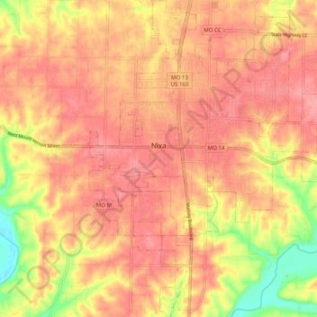
Nom : Carte topographique Nixa, altitude, relief.
Lieu : Nixa, Christian County, Missouri, 65714, United States (37.00122 -93.33579 37.08001 -93.25578)
Altitude moyenne : 380 m
Altitude minimum : 320 m
Altitude maximum : 407 m
Faire un don
Équipez-vous pour votre prochaine aventure :
En tant que Partenaire Amazon, ce site perçoit une commission sur les achats éligibles sans surcoût pour vous.
Autres cartes topographiques
Cliquez sur une carte pour visualiser sa topographie, son altitude et son relief.