
Carte topographique Town of Mount Pleasant
Carte interactive
Cliquez sur la carte pour afficher l’altitude.
À propos de cette carte
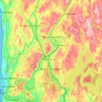
Nom : Carte topographique Town of Mount Pleasant, altitude, relief.
Altitude moyenne : 116 m
Altitude minimum : 0 m
Altitude maximum : 227 m
Autres cartes topographiques
Cliquez sur une carte pour visualiser sa topographie, son altitude et son relief.
Village of Pleasantville
United States > New York > Westchester County > Town of Mount Pleasant > Village of Pleasantville
Village of Pleasantville, Town of Mount Pleasant, Westchester County, New York, 10570, United States
Altitude moyenne : 124 m
Thornwood
United States > New York > Westchester County > Town of Mount Pleasant > Thornwood
Thornwood, Town of Mount Pleasant, Westchester County, New York, 10594, United States
Altitude moyenne : 121 m