
Carte topographique Tongass National Forest
Carte interactive
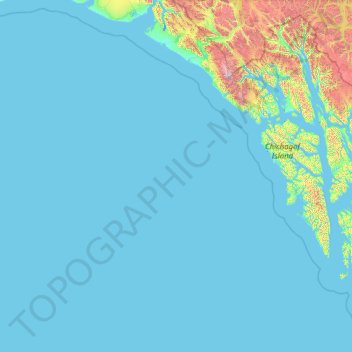
Cliquez sur la carte pour afficher l’altitude.
À propos de cette carte
Nom : Carte topographique Tongass National Forest, altitude, relief.
Altitude moyenne : 156 m
Altitude minimum : -4 m
Altitude maximum : 4 094 m
Historically, logging operations tended to concentrate on lower-elevation, bigger-tree ecosystems for harvesting; at present, approximately 78% of the land remains intact, i.e. 383,000 acres (1,550 km2) out of 491,000 acres (1,990 km2) original big-tree, low-elevation forest area. Given the high value of these areas for wildlife species, close to 70% of this old growth forest is protected in reserves and will never be eligible for harvest.
Autres cartes topographiques
Cliquez sur une carte pour visualiser sa topographie, son altitude et son relief.
Clarence Kramer Peak
United States > Alaska > Sitka > Sitka
Clarence Kramer Peak, Sitka, Alaska, United States
Altitude moyenne : 751 m
North Sister
United States > Alaska > Sitka > Sitka
North Sister, Sitka, Alaska, United States
Altitude moyenne : 507 m
Beaver Lake
United States > Alaska > Sitka > Sitka
Beaver Lake, Sitka, Alaska, United States
Altitude moyenne : 313 m
Fleming Island
United States > Alaska > Sitka
Fleming Island, Sitka, Alaska, United States
Altitude moyenne : 149 m
Mount Edgecumbe
United States > Alaska > Sitka
Mount Edgecumbe, Sitka, Alaska, United States
Altitude moyenne : 597 m