
Carte topographique Kanye
Carte interactive
Cliquez sur la carte pour afficher l’altitude.
À propos de cette carte
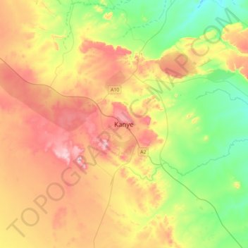
Nom : Carte topographique Kanye, altitude, relief.
Lieu : Kanye, Southern District, Botswana (-25.13661 25.17589 -24.81661 25.49589)
Altitude moyenne : 1 263 m
Altitude minimum : 1 104 m
Altitude maximum : 1 469 m
Autres cartes topographiques
Cliquez sur une carte pour visualiser sa topographie, son altitude et son relief.
Jwaneng
Botswana > Southern District > Jwaneng
Jwaneng, Southern District, Botswana
Altitude moyenne : 1 193 m