
Carte topographique Window Rock
Carte interactive
Cliquez sur la carte pour afficher l’altitude.
À propos de cette carte
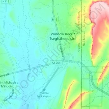
Nom : Carte topographique Window Rock, altitude, relief.
Lieu : Window Rock, Apache County, Arizona, United States (35.63842 -109.08296 35.69519 -109.04629)
Altitude moyenne : 2 084 m
Altitude minimum : 2 034 m
Altitude maximum : 2 247 m
Window Rock is categorized as being within the 6a USDA hardiness zone, meaning the average annual extreme minimum temperature is between −10 and −5 °F (−23 and −21 °C). The city is cooler than most of Arizona due to its high elevation.
Autres cartes topographiques
Cliquez sur une carte pour visualiser sa topographie, son altitude et son relief.
Concho
United States > Arizona > Apache County
Concho, Apache County, Arizona, 85914, United States
Altitude moyenne : 1 844 m
Fort Defiance
United States > Arizona > Apache County
Fort Defiance, Fort Defiance Agency, Apache County, Arizona, 86504, United States
Altitude moyenne : 2 142 m
Nutrioso
United States > Arizona > Apache County
Nutrioso, Apache County, Arizona, 85932, United States
Altitude moyenne : 2 404 m
Alpine
United States > Arizona > Apache County
Alpine, Apache County, Arizona, 75920, United States
Altitude moyenne : 2 611 m
Ganado
United States > Arizona > Apache County
Ganado, Fort Defiance Agency, Apache County, Arizona, United States
Altitude moyenne : 1 991 m
Tsaile
United States > Arizona > Apache County
Tsaile, Chinle Agency, Apache County, Arizona, United States
Altitude moyenne : 2 158 m
McNary
United States > Arizona > Apache County
McNary, Apache County, Arizona, 85930, United States
Altitude moyenne : 2 228 m
Dennehotso
United States > Arizona > Apache County
Dennehotso, Apache County, Arizona, 86535, United States
Altitude moyenne : 1 539 m
Round Rock
United States > Arizona > Apache County
Round Rock, Chinle Agency, Apache County, Arizona, 86547, United States
Altitude moyenne : 1 664 m
Burnside
United States > Arizona > Apache County
Burnside, Fort Defiance Agency, Apache County, Arizona, United States
Altitude moyenne : 1 956 m
Houck
United States > Arizona > Apache County
Houck, Fort Defiance Agency, Apache County, Arizona, United States
Altitude moyenne : 1 890 m
Lukachukai
United States > Arizona > Apache County
Lukachukai, Chinle Agency, Apache County, Arizona, 86507, United States
Altitude moyenne : 2 004 m
Many Farms
United States > Arizona > Apache County
Many Farms, Chinle Agency, Apache County, Arizona, 86538, United States
Altitude moyenne : 1 625 m
Rock Point
United States > Arizona > Apache County
Rock Point, Shiprock Agency, Apache County, Arizona, United States
Altitude moyenne : 1 536 m
Sanders
United States > Arizona > Apache County
Sanders, Apache County, Arizona, 86512, United States
Altitude moyenne : 1 801 m
Blue Gap
United States > Arizona > Apache County
Blue Gap, Chinle Agency, Apache County, Arizona, 86520, United States
Altitude moyenne : 1 989 m
Cottonwood
United States > Arizona > Apache County
Cottonwood, Chinle Agency, Apache County, Arizona, United States
Altitude moyenne : 1 873 m
Cornfields
United States > Arizona > Apache County
Cornfields, Fort Defiance Agency, Apache County, Arizona, United States
Altitude moyenne : 1 880 m
Del Muerto
United States > Arizona > Apache County
Del Muerto, Chinle Agency, Apache County, Arizona, United States
Altitude moyenne : 1 956 m
Teec Nos Pos
United States > Arizona > Apache County
Teec Nos Pos, Shiprock Agency, Apache County, Arizona, United States
Altitude moyenne : 1 620 m
Chinle Agency
United States > Arizona > Apache County
Chinle Agency, Apache County, Arizona, United States
Altitude moyenne : 1 966 m
Vernon
United States > Arizona > Apache County
Vernon, Apache County, Arizona, 89540, United States
Altitude moyenne : 2 119 m
Eagar
United States > Arizona > Apache County
Eagar, Apache County, Arizona, 85925, United States
Altitude moyenne : 2 227 m
Window Rock
United States > Arizona > Apache County
Window Rock, Fort Defiance Agency, Apache County, Arizona, United States
Altitude moyenne : 2 084 m
Coyote Springs
United States > Arizona > Apache County
Coyote Springs, Chinle Agency, Apache County, Arizona, United States
Altitude moyenne : 1 743 m
Upper Forest Mountain
United States > Arizona > Apache County
Upper Forest Mountain, Chinle Agency, Apache County, Arizona, United States
Altitude moyenne : 2 279 m
Chambers
United States > Arizona > Apache County
Chambers, Apache County, Arizona, United States
Altitude moyenne : 1 776 m
Fort Defiance Agency
United States > Arizona > Apache County
Fort Defiance Agency, Apache County, Arizona, United States
Altitude moyenne : 1 913 m
Lupton
United States > Arizona > Apache County
Lupton, Fort Defiance Agency, Apache County, Arizona, 86508, United States
Altitude moyenne : 1 942 m
Cerro Hueco
United States > Arizona > Apache County
Cerro Hueco, Apache County, Arizona, United States
Altitude moyenne : 2 105 m
St. Johns
United States > Arizona > Apache County > St. Johns > St. Johns
St. Johns, Apache County, Arizona, 85936, United States
Altitude moyenne : 1 755 m
Hawley Lake
United States > Arizona > Apache County > Hawley Lake
Hawley Lake, Apache County, Arizona, United States
Altitude moyenne : 2 538 m
White Hills
United States > Arizona > Apache County
White Hills, Chinle Agency, Apache County, Arizona, United States
Altitude moyenne : 1 801 m
Greer
United States > Arizona > Apache County
Greer, Apache County, Arizona, 85927, United States
Altitude moyenne : 2 669 m
White Butte
United States > Arizona > Apache County
White Butte, Chinle Agency, Apache County, Arizona, United States
Altitude moyenne : 2 210 m
Petrified Forest National Park
United States > Arizona > Apache County
Petrified Forest National Park, Apache County, Arizona, 86028, United States
Altitude moyenne : 1 722 m
Saint Michaels
United States > Arizona > Apache County
Saint Michaels, Fort Defiance Agency, Apache County, Arizona, 86511, United States
Altitude moyenne : 2 059 m
Springerville
United States > Arizona > Apache County
Springerville, Apache County, Arizona, United States
Altitude moyenne : 2 150 m
St. Johns
United States > Arizona > Apache County
St. Johns, Apache County, Arizona, 85936, United States
Altitude moyenne : 1 757 m
Steamboat
United States > Arizona > Apache County
Steamboat, Fort Defiance Agency, Apache County, Arizona, United States
Altitude moyenne : 1 969 m
Chinle
United States > Arizona > Apache County
Chinle, Chinle Agency, Apache County, Arizona, United States
Altitude moyenne : 1 715 m
Red Rock
United States > Arizona > Apache County
Red Rock, Shiprock Agency, Apache County, Arizona, United States
Altitude moyenne : 1 780 m