
Carte topographique Huanchaquito
Carte interactive
Cliquez sur la carte pour afficher l’altitude.
À propos de cette carte
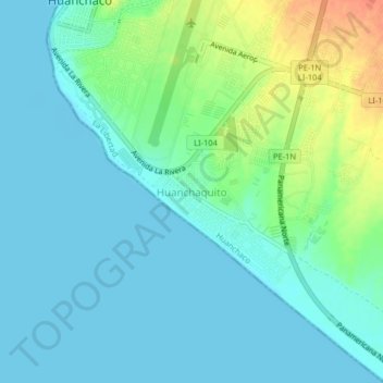
Nom : Carte topographique Huanchaquito, altitude, relief.
Lieu : Huanchaquito, Huanchaco, Trujillo, La Libertad, 13000, Perú (-8.11952 -79.12846 -8.07952 -79.08846)
Altitude moyenne : 12 m
Altitude minimum : -1 m
Altitude maximum : 48 m
Autres cartes topographiques
Cliquez sur une carte pour visualiser sa topographie, son altitude et son relief.
Zona Arqueológica de Chan Chan
Perú > La Libertad > Huanchaco
Zona Arqueológica de Chan Chan, Huanchaco, Trujillo, La Libertad, Perú
Altitude moyenne : 25 m
Chan Chan
Perú > La Libertad > Huanchaco
Chan Chan, Panamericana Norte, Huanchaco, Trujillo, La Libertad, 13011, Perú
Altitude moyenne : 27 m
Huancarute
Perú > La Libertad > Huanchaco
Huancarute, Huanchaco, Trujillo, La Libertad, Perú
Altitude moyenne : 9 m