
Carte topographique Duchesne County
Carte interactive
Cliquez sur la carte pour afficher l’altitude.
À propos de cette carte
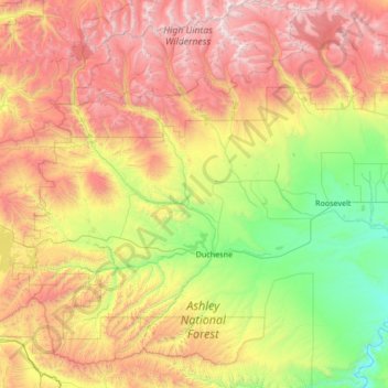
Nom : Carte topographique Duchesne County, altitude, relief.
Lieu : Duchesne County, Utah, United States of America (39.80617 -110.90499 40.83482 -109.97692)
Altitude moyenne : 2 408 m
Altitude minimum : 1 408 m
Altitude maximum : 4 096 m
Autres cartes topographiques
Cliquez sur une carte pour visualiser sa topographie, son altitude et son relief.
Utah County
United States of America > Utah
Utah County, Utah, United States of America
Altitude moyenne : 2 062 m
Box Elder County
United States of America > Utah
Box Elder County, Utah, United States of America
Altitude moyenne : 1 519 m
Ephraim
United States of America > Utah > Ephraim
Ephraim, Utah, 84627, United States of America
Altitude moyenne : 1 700 m
Levan
United States of America > Utah > Levan
Levan, Utah, United States of America
Altitude moyenne : 1 624 m
Pioneer Stadium
United States of America > Utah > Ogden
Pioneer Stadium, Ogden, Weber County, Utah, United States of America
Altitude moyenne : 1 327 m
Tooele County
United States of America > Utah
Tooele County, Utah, United States of America
Altitude moyenne : 1 462 m
Fielding
United States of America > Utah > Fielding > Fielding
Fielding, Box Elder County, Utah, 84311, United States of America
Altitude moyenne : 1 329 m
Daggett County
United States of America > Utah
Daggett County, Utah, 84023, United States of America
Altitude moyenne : 2 267 m