
Carte topographique Missy
Carte interactive
Cliquez sur la carte pour afficher l’altitude.
À propos de cette carte
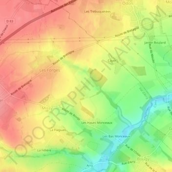
Nom : Carte topographique Missy, altitude, relief.
Altitude moyenne : 102 m
Altitude minimum : 48 m
Altitude maximum : 134 m
Autres cartes topographiques
Cliquez sur une carte pour visualiser sa topographie, son altitude et son relief.
Ragny
France > Normandie > Calvados > Val d'Arry > Tournay-sur-Odon
Ragny, Tournay-sur-Odon, Val d'Arry, Vire, Calvados, Normandie, France métropolitaine, 14310, France
Altitude moyenne : 111 m
Tournay-sur-Odon
France > Normandie > Calvados > Val d'Arry
Tournay-sur-Odon, Val d'Arry, Vire, Calvados, Normandie, France métropolitaine, 14310, France
Altitude moyenne : 121 m
La Cour d'Arry
France > Normandie > Calvados > Val d'Arry > Le Locheur > La Cour d'Arry
La Cour d'Arry, Le Locheur, Val d'Arry, Vire, Calvados, Normandie, France métropolitaine, 14210, France
Altitude moyenne : 94 m