
Carte topographique Kinder Scout
Cliquez sur la carte pour afficher l’altitude.
Kinder Scout
To the north across the Snake Pass lie the high moors of Bleaklow and Black Hill, which are of similar elevation.
À propos de cette carte
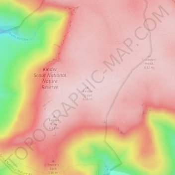
Nom : Carte topographique Kinder Scout, altitude, relief.
Altitude moyenne : 555 m
Altitude minimum : 323 m
Altitude maximum : 638 m
Autres cartes topographiques
Cliquez sur une carte pour visualiser sa topographie, son altitude et son relief.
Buxton
United Kingdom > England > Derbyshire > High Peak
Buxton has an oceanic climate with short, mild summers and long, cool winters. At about 1,000 feet (300 m) above sea level, As the highest market town in England, Buxton's elevation makes it cooler and wetter than surrounding towns, with a daytime temperature typically about 2 °C lower than Manchester.
Altitude moyenne : 334 m
New Mills
United Kingdom > England > Derbyshire > High Peak > Hague Bar
High Peak Borough Council have produced a Conservation Area Character Appraisal document, outlining the reasons that the Conservation Area has been designated as such. In justifying the reasons for designation, this document states of the town: "New Mills is a town of dramatic topography and origins that date…
Altitude moyenne : 251 m
Crowden Great Brook
United Kingdom > England > Derbyshire > High Peak > Tintwistle > Crowden
Altitude moyenne : 314 m
Chapel-en-le-Frith
United Kingdom > England > Derbyshire > High Peak
In the rolling hills between Combs and Chapel is Bank Hall, extensively altered in 1872–74 for Henry Renshaw of Manchester on an ornate aerial plan with an elaborate stone balcony over the door, a bay window with fine botanical painted glass and canvas panels to the doors, formerly with painted panels by…
Altitude moyenne : 324 m
Kinder Scout National Nature Reserve
United Kingdom > England > Derbyshire > High Peak > Hayfield
Altitude moyenne : 513 m
Chisworth
United Kingdom > England > Derbyshire > High Peak > Higher Chisworth
Altitude moyenne : 218 m
Derwent
United Kingdom > England > Derbyshire > High Peak > Bamford > Yorkshire Bridge
Altitude moyenne : 287 m
Crowden Great Brook
United Kingdom > England > Derbyshire > High Peak > Tintwistle
Altitude moyenne : 459 m
Bamford Edge
United Kingdom > England > Derbyshire > High Peak > Bamford > Yorkshire Bridge
Altitude moyenne : 288 m
Shireowlers South Plantation
United Kingdom > England > Derbyshire > High Peak
Altitude moyenne : 342 m
Buxton
United Kingdom > England > Derbyshire > High Peak
Buxton has an oceanic climate with short, mild summers and long, cool winters. At about 1,000 feet (300 m) above sea level, Buxton is the highest market town in England. Buxton's elevation makes it cooler and wetter than surrounding towns, with a daytime temperature typically about 2 °C lower than Manchester.
Altitude moyenne : 334 m
Chapel-en-le-Frith
United Kingdom > England > Derbyshire > High Peak
In the rolling hills between Combs and Chapel is Bank Hall, extensively altered in 1872–74 for Henry Renshaw of Manchester on an ornate aerial plan with an elaborate stone balcony over the door, a bay window with fine botanical painted glass and canvas panels to the doors, formerly with painted panels by…
Altitude moyenne : 324 m
Derwent
United Kingdom > England > Derbyshire > High Peak > Bamford > Yorkshire Bridge
Altitude moyenne : 291 m
New Mills
United Kingdom > England > Derbyshire > High Peak > Hague Bar
High Peak Borough Council have produced a Conservation Area Character Appraisal document, outlining the reasons that the Conservation Area has been designated as such. In justifying the reasons for designation, this document states of the town: "New Mills is a town of dramatic topography and origins that date…
Altitude moyenne : 251 m
Derwent
United Kingdom > England > Derbyshire > High Peak > Bamford > Yorkshire Bridge
Altitude moyenne : 293 m
New Mills
United Kingdom > England > Derbyshire > High Peak
High Peak Borough Council have produced a Conservation Area Character Appraisal document, outlining the reasons that the Conservation Area has been designated as such. In justifying the reasons for designation, this document states of the town: "New Mills is a town of dramatic topography and origins that date…
Altitude moyenne : 229 m
Buxton
United Kingdom > England > Derbyshire > High Peak
Buxton has an oceanic climate with short, mild summers and long, cool winters. At about 1,000 feet (300 m) above sea level, Buxton is the highest market town in England. Buxton's elevation makes it cooler and wetter than surrounding towns, with a daytime temperature typically about 2 °C lower than Manchester.
Altitude moyenne : 334 m