
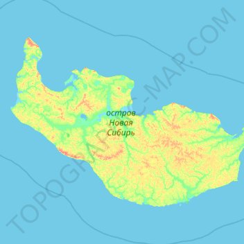
Carte topographique Isla de Nueva Siberia
Carte interactive
Cliquez sur la carte pour afficher l’altitude.
À propos de cette carte
Nom : Carte topographique Isla de Nueva Siberia, altitude, relief.
Altitude moyenne : 4 m
Altitude minimum : -2 m
Altitude maximum : 77 m
Autres cartes topographiques
Cliquez sur une carte pour visualiser sa topographie, son altitude et son relief.
Isla Bolshói Bégichev
Rusia > República de Sajá > Юрюнг-Хаинский национальный наслег
Isla Bolshói Bégichev, Юрюнг-Хаинский национальный наслег, Анабарский национальный улус, República de Sajá, Distrito federal del Lejano Oriente, Rusia
Altitude moyenne : 22 m
Río Indigirka
Río Indigirka, Абыйский улус, República de Sajá, Distrito federal del Lejano Oriente, 678892, Rusia
Altitude moyenne : 435 m
Олёкма
Олёкма, Нерюнгринский улус, República de Sajá, Distrito federal del Lejano Oriente, 673840, Rusia
Altitude moyenne : 806 m
Аллаиховский улус
Аллаиховский улус, República de Sajá, Distrito federal del Lejano Oriente, Rusia
Altitude moyenne : 44 m
Марха
Марха, Олёкминский улус, República de Sajá, Distrito federal del Lejano Oriente, Rusia
Altitude moyenne : 371 m
Яна
Rusia > República de Sajá > Эгинский наслег
Яна, Эгинский наслег, Верхоянский улус, República de Sajá, Distrito federal del Lejano Oriente, Rusia
Altitude moyenne : 67 m
Сартанг
Сартанг, Верхоянский улус, República de Sajá, Distrito federal del Lejano Oriente, Rusia
Altitude moyenne : 765 m
Булунский улус
Булунский улус, República de Sajá, Distrito federal del Lejano Oriente, Rusia
Altitude moyenne : 124 m
Алдан
Алдан, Алданский улус, República de Sajá, Distrito federal del Lejano Oriente, 678954, Rusia
Altitude moyenne : 461 m
Isla Kotelny
Isla Kotelny, Булунский улус, República de Sajá, Distrito federal del Lejano Oriente, Rusia
Altitude moyenne : 14 m
Вилюй
Вилюй, Мирнинский улус, República de Sajá, Distrito federal del Lejano Oriente, 678274, Rusia
Altitude moyenne : 343 m