
Carte topographique Town of Bolton
Carte interactive
Cliquez sur la carte pour afficher l’altitude.
À propos de cette carte
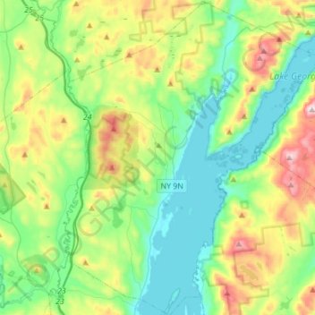
Nom : Carte topographique Town of Bolton, altitude, relief.
Lieu : Town of Bolton, Warren County, New York, United States (43.44207 -73.75035 43.67838 -73.52540)
Altitude moyenne : 297 m
Altitude minimum : 80 m
Altitude maximum : 791 m
Autres cartes topographiques
Cliquez sur une carte pour visualiser sa topographie, son altitude et son relief.
Silver Bay
United States > New York > Warren County
Silver Bay, Town of Hague, Warren County, New York, 12874, United States
Altitude moyenne : 218 m
Height of Land Mountain
United States > New York > Warren County > Town of Johnsburg
Height of Land Mountain, Town of Johnsburg, Warren County, New York, United States
Altitude moyenne : 759 m
Burnt Pond
United States > New York > Warren County
Burnt Pond, Town of Horicon, Warren County, New York, United States
Altitude moyenne : 324 m
Diamond Point (hamlet)
United States > New York > Warren County > Town of Lake George
Diamond Point (hamlet), Town of Lake George, Warren County, New York, 12824, United States
Altitude moyenne : 191 m
Lake George
United States > New York > Warren County > Town of Bolton
Lake George, Town of Bolton, Warren County, New York, United States
Altitude moyenne : 247 m