
Carte topographique Zeandale
Carte interactive
Cliquez sur la carte pour afficher l’altitude.
À propos de cette carte
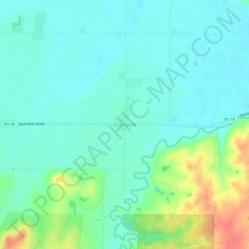
Nom : Carte topographique Zeandale, altitude, relief.
Lieu : Zeandale, Riley County, Kansas, United States (39.13944 -96.44667 39.17944 -96.40667)
Altitude moyenne : 314 m
Altitude minimum : 298 m
Altitude maximum : 357 m
Autres cartes topographiques
Cliquez sur une carte pour visualiser sa topographie, son altitude et son relief.
Ogden
United States > Kansas > Riley County
Ogden, Riley County, Kansas, 66517, United States
Altitude moyenne : 327 m
Manhattan
United States > Kansas > Riley County > Manhattan
Manhattan, Riley County, Kansas, 66502-6322, United States
Altitude moyenne : 365 m
Tuttle Creek Lake
United States > Kansas > Riley County
Tuttle Creek Lake, Riley County, Kansas, United States
Altitude moyenne : 383 m
Manhattan
United States > Kansas > Riley County
Manhattan, Riley County, Kansas, United States
Altitude moyenne : 344 m