
Carte topographique Kavala
Carte interactive
Cliquez sur la carte pour afficher l’altitude.
À propos de cette carte
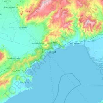
Nom : Carte topographique Kavala, altitude, relief.
Altitude moyenne : 173 m
Altitude minimum : -3 m
Altitude maximum : 984 m
On July 16, 2022, Meridian Flight 3032 crashed near the village. The Ukrainian-registered Antonov An-12BK was carrying 11.5 tons of ammunition from Nis to Dhaka when the plane began to lose altitude over the Aegean and turned around, but went down 35 kilometers west of Kavala Airport. All 8 crew members were killed.
Autres cartes topographiques
Cliquez sur une carte pour visualiser sa topographie, son altitude et son relief.
Nea Peramos
Greece > Macedonia and Thrace > Kavala Regional Unit
Nea Peramos, Paggaio Municipality, Kavala Regional Unit, Eastern Macedonia and Thrace, Macedonia and Thrace, 640 07, Greece
Altitude moyenne : 41 m