
Carte topographique Flinders Ranges
Carte interactive
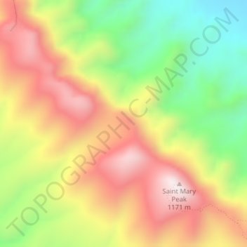
Cliquez sur la carte pour afficher l’altitude.
À propos de cette carte
Nom : Carte topographique Flinders Ranges, altitude, relief.
Altitude moyenne : 808 m
Altitude minimum : 461 m
Altitude maximum : 1 142 m
Autres cartes topographiques
Cliquez sur une carte pour visualiser sa topographie, son altitude et son relief.
Nadia
Australien > Südaustralien > The District Council of Ceduna
Nadia, The District Council of Ceduna, Südaustralien, 5690, Australien
Altitude moyenne : 11 m
Maralinga Village
Australien > Südaustralien > Maralinga Tjarutja
Maralinga Village, Maralinga Tjarutja, Südaustralien, Australien
Altitude moyenne : 279 m
Tarpeena
Tarpeena, The District Council of Grant, Südaustralien, 5277, Australien
Altitude moyenne : 71 m
Hallett Cove Conservation Park
Australien > Südaustralien > Adelaide
Hallett Cove Conservation Park, Cherub Street, Hallett Cove, Adelaide, City of Marion, Südaustralien, 5158, Australien
Altitude moyenne : 42 m
Streaky Bay
Australien > Südaustralien > The District Council of Streaky Bay
Streaky Bay, The District Council of Streaky Bay, Südaustralien, 5680, Australien
Altitude moyenne : 14 m
Pewsey Vale
Pewsey Vale, The Barossa Council, Südaustralien, 5351, Australien
Altitude moyenne : 429 m
Barossa Valley District
Australien > Südaustralien > Mid Murray Council
Barossa Valley District, Mid Murray Council, Südaustralien, Australien
Altitude moyenne : 294 m
Cleland
Cleland, Adelaide Hills Council, Südaustralien, 5152, Australien
Altitude moyenne : 491 m
Oakbank
Australien > Südaustralien > Oakbank
Oakbank, Adelaide Hills Council, Südaustralien, 5243, Australien
Altitude moyenne : 382 m
Mount Gambier
Mount Gambier, City of Mount Gambier, Südaustralien, 5290, Australien
Altitude moyenne : 50 m
Streaky Bay
Australien > Südaustralien > The District Council of Streaky Bay > Streaky Bay
Streaky Bay, The District Council of Streaky Bay, Südaustralien, Australien
Altitude moyenne : 22 m
Adelaide
Australien > Südaustralien > Adelaide City Council
Adelaide, Adelaide City Council, Südaustralien, Australien
Altitude moyenne : 146 m
Wanbi
Australien > Südaustralien > The District Council of Karoonda East Murray > Wanbi
Wanbi, The District Council of Karoonda East Murray, Südaustralien, 5310, Australien
Altitude moyenne : 74 m
Katunga
Australien > Südaustralien > Pastoral Unincorporated Area
Katunga, Pastoral Unincorporated Area, Südaustralien, Australien
Altitude moyenne : 176 m
Tarcoola
Australien > Südaustralien > Tarcoola
Tarcoola, Pastoral Unincorporated Area, Südaustralien, 5701, Australien
Altitude moyenne : 128 m
Lake Eyre
Lake Eyre, Pastoral Unincorporated Area, Südaustralien, 5733, Australien
Altitude moyenne : 9 m
Mount Schank
Mount Schank, The District Council of Grant, Südaustralien, Australien
Altitude moyenne : 25 m
Clare And Gilbert Valleys
Clare And Gilbert Valleys, Südaustralien, Australien
Altitude moyenne : 306 m
Port Augusta
Port Augusta, Südaustralien, 5700, Australien
Altitude moyenne : 9 m
Brompton
Brompton, Charles Sturt, Südaustralien, 5007, Australien
Altitude moyenne : 24 m
Gammon Ranges
Gammon Ranges, PUA, Südaustralien, 5732, Australien
Altitude moyenne : 325 m
Tanunda
Tanunda, The Barossa Council, Südaustralien, 5352, Australien
Altitude moyenne : 276 m
Adelaide Hills Council
Adelaide Hills Council, Südaustralien, Australien
Altitude moyenne : 305 m
City of Onkaparinga
City of Onkaparinga, Südaustralien, Australien
Altitude moyenne : 180 m
The District Council of Streaky Bay
The District Council of Streaky Bay, Südaustralien, Australien
Altitude moyenne : 63 m
Lake Frome
Lake Frome, PUA, Südaustralien, 5440, Australien
Altitude moyenne : 36 m
Lake Gairdner
Lake Gairdner, PUA, Südaustralien, 5717, Australien
Altitude moyenne : 145 m
Mount Denison
Mount Denison, PUA, Südaustralien, Australien
Altitude moyenne : 170 m
McLaren Vale
Australien > Südaustralien > Adelaide > McLaren Vale
McLaren Vale, Adelaide, City of Onkaparinga, Südaustralien, 5171, Australien
Altitude moyenne : 90 m
Känguru-Insel
Känguru-Insel, Kangaroo Island, Südaustralien, Australien
Altitude moyenne : 22 m
Piednippie
Piednippie, The District Council of Streaky Bay, Südaustralien, 5680, Australien
Altitude moyenne : 43 m
The Barossa Council
The Barossa Council, Südaustralien, Australien
Altitude moyenne : 308 m
Lake Torrens
Lake Torrens, PUA, Südaustralien, 5713, Australien
Altitude moyenne : 177 m