
Carte topographique Drăgănești-Olt
Carte interactive
Cliquez sur la carte pour afficher l’altitude.
À propos de cette carte
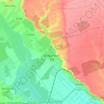
Nom : Carte topographique Drăgănești-Olt, altitude, relief.
Lieu : Drăgănești-Olt, Olt, Romania (44.12293 24.46656 44.22532 24.61533)
Altitude moyenne : 101 m
Altitude minimum : 59 m
Altitude maximum : 148 m
The town is situated on the Wallachian Plain. It lies on the left bank of the river Olt, at an altitude of approximately 100 m (330 ft). It is located in the central part of Olt County, at a distance of 35 km (22 mi) from the county seat, Slatina, and 65 km (40 mi) north of Turnu Măgurele.
Autres cartes topographiques
Cliquez sur une carte pour visualiser sa topographie, son altitude et son relief.