
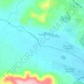
Carte topographique Swartkops River
Carte interactive
Cliquez sur la carte pour afficher l’altitude.
À propos de cette carte
Nom : Carte topographique Swartkops River, altitude, relief.
Altitude moyenne : 83 m
Altitude minimum : 39 m
Altitude maximum : 270 m
Autres cartes topographiques
Cliquez sur une carte pour visualiser sa topographie, son altitude et son relief.
Nelson Mandela Bay Ward 42
RSA > Eastern Cape > Port Elizabeth
Nelson Mandela Bay Ward 42, Port Elizabeth, Nelson Mandela Bay Metropolitan Municipality, Eastern Cape, RSA
Altitude moyenne : 124 m
Nelson Mandela Bay Ward 1
RSA > Eastern Cape > Port Elizabeth
Nelson Mandela Bay Ward 1, Port Elizabeth, Nelson Mandela Bay Metropolitan Municipality, Eastern Cape, 6070, RSA
Altitude moyenne : 76 m
Brenton Island
RSA > Eastern Cape > Port Elizabeth
Brenton Island, Port Elizabeth, Eastern Cape, RSA
Altitude moyenne : 0 m
Nelson Mandela Bay Ward 41
RSA > Eastern Cape > Port Elizabeth
Nelson Mandela Bay Ward 41, Port Elizabeth, Nelson Mandela Bay Metropolitan Municipality, Eastern Cape, RSA
Altitude moyenne : 105 m
Jahleel Island
RSA > Eastern Cape > Port Elizabeth
Jahleel Island, Port Elizabeth, Eastern Cape, RSA
Altitude moyenne : 1 m