
Carte topographique Мяндиги
Carte interactive
Cliquez sur la carte pour afficher l’altitude.
À propos de cette carte
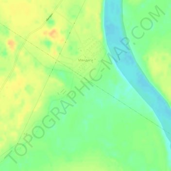
Nom : Carte topographique Мяндиги, altitude, relief.
Altitude moyenne : 135 m
Altitude minimum : 120 m
Altitude maximum : 150 m
Autres cartes topographiques
Cliquez sur une carte pour visualiser sa topographie, son altitude et son relief.
Amga
Russia > Sakha Republic > Amginsky Ulus
Amga, Амгинский наслег, Amginsky Ulus, Sakha Republic, Far Eastern Federal District, 678600, Russia
Altitude moyenne : 161 m