
Carte topographique Tickhill
Carte interactive
Cliquez sur la carte pour afficher l’altitude.
À propos de cette carte
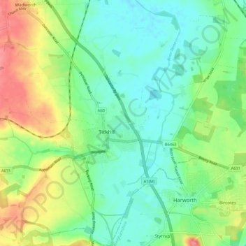
Nom : Carte topographique Tickhill, altitude, relief.
Lieu : Tickhill, Doncaster, South Yorkshire, England, United Kingdom (53.40574 -1.15179 53.46823 -1.05201)
Altitude moyenne : 28 m
Altitude minimum : 3 m
Altitude maximum : 76 m
It lies eight miles south of Doncaster, between Maltby and Harworth, on the busy conjunction of the A631 and A60 roads, and adjacent to the A1(M) motorway. It is located at 53° 26' North, 1° 6' 40" West, at an elevation of around 20 metres above sea level. The River Torne passes close to the south-east of the town where it is the boundary between South Yorkshire and Nottinghamshire, eventually meeting the River Trent.