
Faire un don
Équipez-vous pour votre prochaine aventure :
En tant que Partenaire Amazon, ce site perçoit une commission sur les achats éligibles sans surcoût pour vous.
Carte topographique Lonau
Cliquez sur la carte pour afficher l’altitude.
Faire un don
Équipez-vous pour votre prochaine aventure :
En tant que Partenaire Amazon, ce site perçoit une commission sur les achats éligibles sans surcoût pour vous.
Lonau
Lonau is a small village with a population of about 345 situated at an elevation of about 400m in the Harz Mountains of Northern Germany. Besides the clean air and lush forests, it is famous for the capercaillie. It belongs to the city of Herzberg am Harz which is about 4 km to the south. The rivers Große Lonau and Kleine Lonau join here.
Faire un don
Équipez-vous pour votre prochaine aventure :
En tant que Partenaire Amazon, ce site perçoit une commission sur les achats éligibles sans surcoût pour vous.
À propos de cette carte
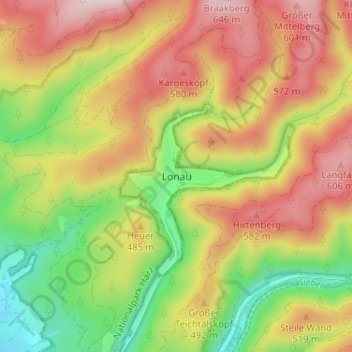
Nom : Carte topographique Lonau, altitude, relief.
Altitude moyenne : 446 m
Altitude minimum : 247 m
Altitude maximum : 641 m
Faire un don
Équipez-vous pour votre prochaine aventure :
En tant que Partenaire Amazon, ce site perçoit une commission sur les achats éligibles sans surcoût pour vous.