
Carte topographique Area F (Columbia Lake/Windermere Lake)
Carte interactive
Cliquez sur la carte pour afficher l’altitude.
À propos de cette carte
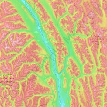
Nom : Carte topographique Area F (Columbia Lake/Windermere Lake), altitude, relief.
Altitude moyenne : 1 815 m
Altitude minimum : 775 m
Altitude maximum : 3 425 m
Autres cartes topographiques
Cliquez sur une carte pour visualiser sa topographie, son altitude et son relief.
Fairmont Hot Springs
Canada > British Columbia > Regional District of East Kootenay > Area F (Columbia Lake/Windermere Lake)
Fairmont Hot Springs, Area F (Columbia Lake/Windermere Lake), Regional District of East Kootenay, British Columbia, V0B 1L0, Canada
Altitude moyenne : 920 m
Whiteswan Lake
Canada > British Columbia > Regional District of East Kootenay > Area F (Columbia Lake/Windermere Lake)
Whiteswan Lake, Area F (Columbia Lake/Windermere Lake), Regional District of East Kootenay, British Columbia, Canada
Altitude moyenne : 1 392 m
Shuswap
Canada > British Columbia > Regional District of East Kootenay > Area F (Columbia Lake/Windermere Lake)
Shuswap, Area F (Columbia Lake/Windermere Lake), Regional District of East Kootenay, British Columbia, V0A 1K3, Canada
Altitude moyenne : 926 m