
Carte topographique Shabramant
Carte interactive
Cliquez sur la carte pour afficher l’altitude.
À propos de cette carte
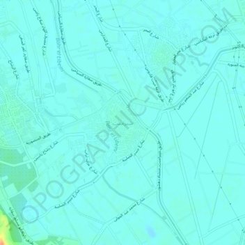
Nom : Carte topographique Shabramant, altitude, relief.
Lieu : Shabramant, Giza, 12947, Egypt (29.92077 31.17012 29.96077 31.21012)
Altitude moyenne : 20 m
Altitude minimum : 14 m
Altitude maximum : 55 m
Autres cartes topographiques
Cliquez sur une carte pour visualiser sa topographie, son altitude et son relief.
Sheikh Zayed City
Egypt > Giza > Sheikh Zayed City
Sheikh Zayed City, Giza, 12593, Egypt
Altitude moyenne : 103 m
El Hassana Dome Protectorate
Egypt > Giza > Sheikh Zayed
El Hassana Dome Protectorate, Sheikh Zayed, Giza, Egypt
Altitude moyenne : 108 m
Al Hosary park
Egypt > Giza > Sixth of October
Al Hosary park, Neighborhood 1, 8th District, Sixth of October, Giza, Egypt
Altitude moyenne : 184 m
Nazlet Al Siman and Al Sisi
Egypt > Giza > Remaya Square
Nazlet Al Siman and Al Sisi, Remaya Square, Giza, Egypt
Altitude moyenne : 42 m